Euan geodata
Euan (Yucatán) is a populated place; located in Mexico in America/Merida (GMT-6) time zone. With population of 1,186 people, there are 7322 cities with bigger population in this country. Compared to other cities in Mexico, 76.4% of cities are located further ↓South; 98.4% of cities are located further ←West and 95.7% of cities have higher elevation than Euan. Note1


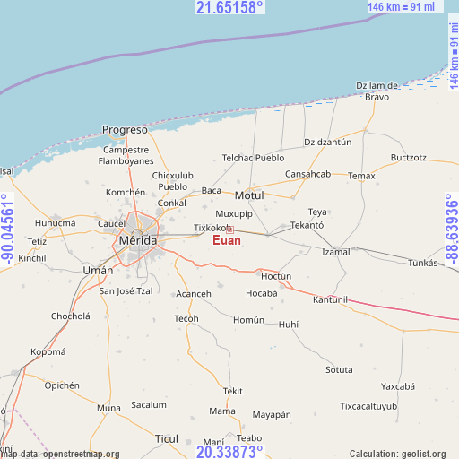
Euan GPS coordinates[2]
20° 59' 47.76" North, 89° 20' 32.928" West
| Map corner | latitude | longitude |
|---|---|---|
| Upper-left | 21.65158°, | -90.04561° |
| Center: | 20.9966°, | -89.34248° |
| Lower-right: | 20.33873°, | -88.63936° |
| Map W x H: | 146×146 km | = 90.7×90.7mi |
| max Lat: | 32.7° ⇑23.6% North |
| Euan: | 20.9966° |
| min Lat: | ⇓76.4% South 14.53588° |
| min Long | Euan | max Long |
| -117.105° | -89.34248° | -86.73105° |
| W 98.4%⇐ | ⇒1.6% E |
Elevation
Elevation of Euan is 12 m = 39 ft, and this is 1241.7 m = 4074 ft below average elevation for this country.
| Max E: |
3497 m = 11473 ft | 95.7% |
| Avg. | 1253.7 m = 4113 ft | |
| Euan | 12 m = 39 ft | |
Min E: |
-1 m = -3 ft | 4.3% |
See also: Mexico elevation on elevation.city.
Geographical zone
Euan is located in North Torrid zone (between Equator and Tropic of Cancer). Distance of this Northern Tropic circle is 271.3 km =168.6 mi to North.| Distance of | km | miles | from Euan |
|---|---|---|---|
| North Pole | 7672.5 | 4767.5 | to North |
| Arctic Circle | 5066.6 | 3148.2 | to North |
| Tropic Cancer | 271.3 | 168.6 | to North |
| Equator | 2334.6 | 1450.7 | to South |


Nearby cities:
15 places around Euan: (largest is in red/bold)
• Baca
13.8 km =8.6 mi,  334°
334°
• Cacalchen
12.1 km =7.5 mi,  96°
96°
• Chochoh
13 km =8.1 mi,  268°
268°
• Cholul Cantón
5.5 km =3.4 mi,  73°
73°
• Ekmul
3.6 km =2.2 mi,  192°
192°
• Holactun
13.4 km =8.3 mi,  173°
173°
• Kopte
13.3 km =8.3 mi,  60°
60°
• Motul
12.6 km =7.8 mi,  29°
29°
• Muxupip
5.3 km =3.3 mi,  15°
15°
• Nolo
8.5 km =5.3 mi,  279°
279°
• San Antonio Millet
6.3 km =3.9 mi,  245°
245°
• Tixkokob
5.5 km =3.4 mi, 276°
• Tixkunchell
10.9 km =6.8 mi, 328°
• Tixpehual
10.6 km =6.6 mi,  258°
258°
• Yaxkukul
10.7 km =6.6 mi,  312°
312°
Sources, notices
• [Note1] Compared only with cities in Mexico existing in our database
• [Src1] Map data: © OpenStreetMap contributors (CC-BY-SA)
• [Src2] Other city data from geonames.org with taken over terms of usage.
• [Src3] Geographical zone / Annual Mean Temperature by Robert A. Rohde @ Wikipedia
