Seybaplaya geodata
Seybaplaya (Campeche) is a populated place; located in Mexico in America/Merida (GMT-6) time zone. With population of 8,711 people, there are 1094 cities with bigger population in this country. Compared to other cities in Mexico, 51.1% of cities are located further ↑North; 97% of cities are located further ←West and 98.7% of cities have higher elevation than Seybaplaya. Note1


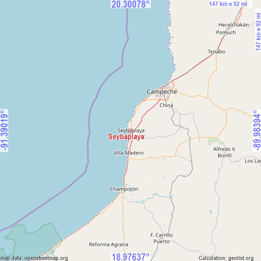
Seybaplaya GPS coordinates[2]
19° 38' 23.784" North, 90° 41' 13.416" West
| Map corner | latitude | longitude |
|---|---|---|
| Upper-left | 20.30078°, | -91.39019° |
| Center: | 19.63994°, | -90.68706° |
| Lower-right: | 18.97637°, | -89.98394° |
| Map W x H: | 147.3×147.3 km | = 91.5×91.5mi |
| max Lat: | 32.7° ⇑51.1% North |
| Seybaplaya: | 19.63994° |
| min Lat: | ⇓48.9% South 14.53588° |
| min Long | Seybaplaya | max Long |
| -117.105° | -90.68706° | -86.73105° |
| W 97%⇐ | ⇒3% E |
Elevation
Elevation of Seybaplaya is 7 m = 23 ft, and this is 1246.7 m = 4090 ft below average elevation for this country.
| Max E: |
3497 m = 11473 ft | 98.7% |
| Avg. | 1253.7 m = 4113 ft | |
| Seybaplaya | 7 m = 23 ft | |
Min E: |
-1 m = -3 ft | 1.3% |
See also: Mexico elevation on elevation.city.
Geographical zone
Seybaplaya is located in North Torrid zone (between Equator and Tropic of Cancer). Distance of this Northern Tropic circle is 422.2 km =262.3 mi to North.| Distance of | km | miles | from Seybaplaya |
|---|---|---|---|
| North Pole | 7823.3 | 4861.2 | to North |
| Arctic Circle | 5217.4 | 3241.9 | to North |
| Tropic Cancer | 422.2 | 262.3 | to North |
| Equator | 2183.8 | 1356.9 | to South |


Nearby cities:
15 places around Seybaplaya: (largest is in red/bold)
• Campeche
28.3 km =17.6 mi,  36°
36°
• Castamay
34.6 km =21.5 mi,  50°
50°
• Champotón
32.7 km =20.3 mi,  186°
186°
• Chiná
24.7 km =15.3 mi, 54°
• Ciudad del Sol
18.1 km =11.2 mi, 185°
• Hool
28.9 km =18 mi,  119°
119°
• La Joya
17.8 km =11.1 mi,  175°
175°
• Lerma
20.4 km =12.7 mi,  26°
26°
• Moquel
32 km =19.9 mi, 177°
• Nohakal
36.8 km =22.9 mi,  87°
87°
• Pocyaxum
36.6 km =22.7 mi,  74°
74°
• Santo Domingo Kesté
24.1 km =15 mi,  130°
130°
• Sihochac
18.8 km =11.7 mi,  145°
145°
• Villa Madero
12.5 km =7.8 mi, 185°
• Xkeulil
6.1 km =3.8 mi,  101°
101°
Sources, notices
• [Note1] Compared only with cities in Mexico existing in our database
• [Src1] Map data: © OpenStreetMap contributors (CC-BY-SA)
• [Src2] Other city data from geonames.org with taken over terms of usage.
• [Src3] Geographical zone / Annual Mean Temperature by Robert A. Rohde @ Wikipedia
