Santo Domingo Kesté geodata
Santo Domingo Kesté (Campeche) is a populated place; located in Mexico in America/Merida (GMT-6) time zone. With population of 3,763 people, there are 2436 cities with bigger population in this country. Compared to other cities in Mexico, 54% of cities are located further ↑North; 97.2% of cities are located further ←West and 89.7% of cities have higher elevation than Santo Domingo Kesté. Note1


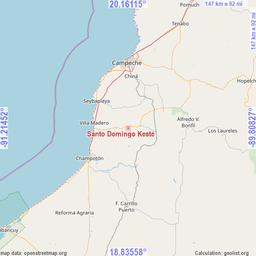
Santo Domingo Kesté GPS coordinates[2]
19° 29' 58.992" North, 90° 30' 41.004" West
| Map corner | latitude | longitude |
|---|---|---|
| Upper-left | 20.16115°, | -91.21452° |
| Center: | 19.49972°, | -90.51139° |
| Lower-right: | 18.83558°, | -89.80827° |
| Map W x H: | 147.4×147.4 km | = 91.6×91.6mi |
| max Lat: | 32.7° ⇑54% North |
| Santo Domingo Kesté: | 19.49972° |
| min Lat: | ⇓46% South 14.53588° |
| min Long | Santo Domingo K | max Long |
| -117.105° | -90.51139° | -86.73105° |
| W 97.2%⇐ | ⇒2.8% E |
Elevation
Elevation of Santo Domingo Kesté is 25 m = 82 ft, and this is 1228.7 m = 4031 ft below average elevation for this country.
| Max E: |
3497 m = 11473 ft | 89.7% |
| Avg. | 1253.7 m = 4113 ft | |
| Santo Domingo Kesté | 25 m = 82 ft | |
Min E: |
-1 m = -3 ft | 10.3% |
See also: Mexico elevation on elevation.city.
Geographical zone
Santo Domingo Kesté is located in North Torrid zone (between Equator and Tropic of Cancer). Distance of this Northern Tropic circle is 437.8 km =272 mi to North.| Distance of | km | miles | from Santo Domingo Kesté |
|---|---|---|---|
| North Pole | 7838.9 | 4870.9 | to North |
| Arctic Circle | 5233 | 3251.6 | to North |
| Tropic Cancer | 437.8 | 272 | to North |
| Equator | 2168.2 | 1347.3 | to South |


Nearby cities:
15 places around Santo Domingo Kesté: (largest is in red/bold)
• Alfredo V. Bonfil
34.7 km =21.6 mi,  84°
84°
• Champotón
27.7 km =17.2 mi,  232°
232°
• Chiná
30.1 km =18.7 mi,  3°
3°
• Ciudad del Sol
20.2 km =12.6 mi,  263°
263°
• Hool
7 km =4.3 mi, 77°
• La Joya
17.1 km =10.6 mi, 262°
• Melchor Ocampo
32.9 km =20.4 mi,  115°
115°
• Moquel
23.5 km =14.6 mi, 226°
• Nohakal
25.2 km =15.7 mi,  46°
46°
• Pocyaxum
30.5 km =19 mi,  33°
33°
• Seybaplaya
24.1 km =15 mi,  310°
310°
• Sihochac
7.7 km =4.8 mi,  271°
271°
• Ulumal
27.9 km =17.3 mi,  204°
204°
• Villa Madero
19.9 km =12.4 mi,  279°
279°
• Xkeulil
19 km =11.8 mi,  319°
319°
Sources, notices
• [Note1] Compared only with cities in Mexico existing in our database
• [Src1] Map data: © OpenStreetMap contributors (CC-BY-SA)
• [Src2] Other city data from geonames.org with taken over terms of usage.
• [Src3] Geographical zone / Annual Mean Temperature by Robert A. Rohde @ Wikipedia
