Champotón geodata
Champotón (Campeche) is a seat of a second-order administrative division; located in Mexico in America/Merida (GMT-6) time zone. With population of 30,881 people, there are 325 cities with bigger population in this country. Compared to other cities in Mexico, 57.7% of cities are located further ↑North; 97% of cities are located further ←West and 99.8% of cities have higher elevation than Champotón. Note1


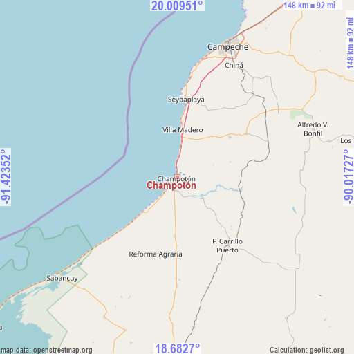
Champotón GPS coordinates[2]
19° 20' 50.82" North, 90° 43' 13.404" West
| Map corner | latitude | longitude |
|---|---|---|
| Upper-left | 20.00951°, | -91.42352° |
| Center: | 19.34745°, | -90.72039° |
| Lower-right: | 18.6827°, | -90.01727° |
| Map W x H: | 147.5×147.5 km | = 91.7×91.7mi |
| max Lat: | 32.7° ⇑57.7% North |
| Champotón: | 19.34745° |
| min Lat: | ⇓42.3% South 14.53588° |
| min Long | Champotón | max Long |
| -117.105° | -90.72039° | -86.73105° |
| W 97%⇐ | ⇒3% E |
Elevation
Elevation of Champotón is 3 m = 10 ft, and this is 1250.7 m = 4103 ft below average elevation for this country.
| Max E: |
3497 m = 11473 ft | 99.8% |
| Avg. | 1253.7 m = 4113 ft | |
| Champotón | 3 m = 10 ft | |
Min E: |
-1 m = -3 ft | 0.2% |
See also: Mexico elevation on elevation.city.
Geographical zone
Champotón is located in North Torrid zone (between Equator and Tropic of Cancer). Distance of this Northern Tropic circle is 454.7 km =282.5 mi to North.| Distance of | km | miles | from Champotón |
|---|---|---|---|
| North Pole | 7855.8 | 4881.4 | to North |
| Arctic Circle | 5249.9 | 3262.1 | to North |
| Tropic Cancer | 454.7 | 282.5 | to North |
| Equator | 2151.2 | 1336.7 | to South |


Nearby cities:
15 places around Champotón: (largest is in red/bold)
• Ciudad del Sol
14.6 km =9.1 mi,  7°
7°
• Hool
34.1 km =21.2 mi,  57°
57°
• José María Morelos y Pavón
28.3 km =17.6 mi,  180°
180°
• La Joya
15.6 km =9.7 mi,  18°
18°
• Maya Tecún I
31.2 km =19.4 mi,  133°
133°
• Maya Tecún II
30.3 km =18.8 mi, 132°
• Moquel
5 km =3.1 mi,  83°
83°
• Pustunich
34 km =21.1 mi, 131°
• San Pablo Pixtún
23.8 km =14.8 mi, 182°
• Santo Domingo Kesté
27.7 km =17.2 mi,  52°
52°
• Seybaplaya
32.7 km =20.3 mi, 6°
• Sihochac
22.2 km =13.8 mi,  39°
39°
• Ulumal
13.2 km =8.2 mi, 129°
• Villa Madero
20.2 km =12.6 mi, 6°
• Xkeulil
32.7 km =20.3 mi, 16°
Sources, notices
• [Note1] Compared only with cities in Mexico existing in our database
• [Src1] Map data: © OpenStreetMap contributors (CC-BY-SA)
• [Src2] Other city data from geonames.org with taken over terms of usage.
• [Src3] Geographical zone / Annual Mean Temperature by Robert A. Rohde @ Wikipedia
