Lerma geodata
Lerma (Campeche) is a populated place; located in Mexico in America/Merida (GMT-6) time zone. With population of 8,281 people, there are 1149 cities with bigger population in this country. Compared to other cities in Mexico, 52.9% of cities are located further ↓South; 97.1% of cities are located further ←West and 98.1% of cities have higher elevation than Lerma. Note1


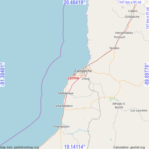
Lerma GPS coordinates[2]
19° 48' 14.544" North, 90° 36' 3.168" West
| Map corner | latitude | longitude |
|---|---|---|
| Upper-left | 20.46419°, | -91.30401° |
| Center: | 19.80404°, | -90.60088° |
| Lower-right: | 19.14114°, | -89.89776° |
| Map W x H: | 147.1×147.1 km | = 91.4×91.4mi |
| max Lat: | 32.7° ⇑47.1% North |
| Lerma: | 19.80404° |
| min Lat: | ⇓52.9% South 14.53588° |
| min Long | Lerma | max Long |
| -117.105° | -90.60088° | -86.73105° |
| W 97.1%⇐ | ⇒2.9% E |
Elevation
Elevation of Lerma is 8 m = 26 ft, and this is 1245.7 m = 4087 ft below average elevation for this country.
| Max E: |
3497 m = 11473 ft | 98.1% |
| Avg. | 1253.7 m = 4113 ft | |
| Lerma | 8 m = 26 ft | |
Min E: |
-1 m = -3 ft | 1.9% |
See also: Mexico elevation on elevation.city.
Geographical zone
Lerma is located in North Torrid zone (between Equator and Tropic of Cancer). Distance of this Northern Tropic circle is 403.9 km =251 mi to North.| Distance of | km | miles | from Lerma |
|---|---|---|---|
| North Pole | 7805.1 | 4849.9 | to North |
| Arctic Circle | 5199.2 | 3230.6 | to North |
| Tropic Cancer | 403.9 | 251 | to North |
| Equator | 2202 | 1368.3 | to South |


Nearby cities:
15 places around Lerma: (largest is in red/bold)
• Bethania
27.1 km =16.8 mi,  64°
64°
• Campeche
9 km =5.6 mi, 60°
• Castamay
18.1 km =11.2 mi,  78°
78°
• Chemblás
28.7 km =17.8 mi, 63°
• Chiná
11.6 km =7.2 mi,  109°
109°
• Hampolol
26 km =16.2 mi, 58°
• Nilchí
34.8 km =21.6 mi, 82°
• Nohakal
32.4 km =20.1 mi,  120°
120°
• Pocyaxum
27.5 km =17.1 mi, 107°
• San Francisco Kobén
22.8 km =14.2 mi, 57°
• Santo Domingo Kesté
35.1 km =21.8 mi,  164°
164°
• Seybaplaya
20.4 km =12.7 mi,  206°
206°
• Sihochac
33.7 km =20.9 mi,  177°
177°
• Villa Madero
32.3 km =20.1 mi,  198°
198°
• Xkeulil
19.7 km =12.2 mi,  188°
188°
Sources, notices
• [Note1] Compared only with cities in Mexico existing in our database
• [Src1] Map data: © OpenStreetMap contributors (CC-BY-SA)
• [Src2] Other city data from geonames.org with taken over terms of usage.
• [Src3] Geographical zone / Annual Mean Temperature by Robert A. Rohde @ Wikipedia
