San Vicente de Juárez geodata
San Vicente de Juárez (Morelos) is a populated place; located in Mexico in America/Mexico_City (GMT-6) time zone. With population of 1,375 people, there are 6311 cities with bigger population in this country. Compared to other cities in Mexico, 70.4% of cities are located further ↑North; 50.4% of cities are located further ←West and 58.4% of cities have higher elevation than San Vicente de Juárez. Note1


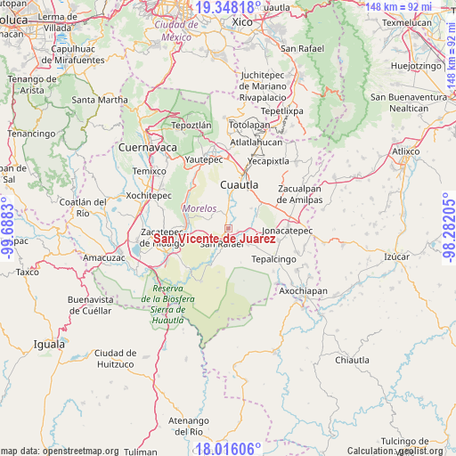
San Vicente de Juárez GPS coordinates[2]
18° 41' 0.348" North, 98° 59' 6.612" West
| Map corner | latitude | longitude |
|---|---|---|
| Upper-left | 19.34818°, | -99.6883° |
| Center: | 18.68343°, | -98.98517° |
| Lower-right: | 18.01606°, | -98.28205° |
| Map W x H: | 148.1×148.1 km | = 92×92mi |
| max Lat: | 32.7° ⇑70.4% North |
| San Vicente de Juárez: | 18.68343° |
| min Lat: | ⇓29.6% South 14.53588° |
| min Long | San Vicente de | max Long |
| -117.105° | -98.98517° | -86.73105° |
| W 50.4%⇐ | ⇒49.6% E |
Elevation
Elevation of San Vicente de Juárez is 1087 m = 3566 ft, and this is 166.7 m = 547 ft below average elevation for this country.
| Max E: |
3497 m = 11473 ft | 58.4% |
| Avg. | 1253.7 m = 4113 ft | |
| San Vicente de Juárez | 1087 m = 3566 ft | |
Min E: |
-1 m = -3 ft | 41.6% |
See also: Mexico elevation on elevation.city.
Geographical zone
San Vicente de Juárez is located in North Torrid zone (between Equator and Tropic of Cancer). Distance of this Northern Tropic circle is 528.5 km =328.4 mi to North.| Distance of | km | miles | from San Vicente de Juárez |
|---|---|---|---|
| North Pole | 7929.7 | 4927.3 | to North |
| Arctic Circle | 5323.8 | 3308.1 | to North |
| Tropic Cancer | 528.5 | 328.4 | to North |
| Equator | 2077.4 | 1290.8 | to South |


Nearby cities:
15 places around San Vicente de Juárez: (largest is in red/bold)
• Abelardo L. Rodríguez
6 km =3.7 mi,  359°
359°
• Chinameca
6.9 km =4.3 mi,  190°
190°
• Ciudad Ayala
9.3 km =5.8 mi,  1°
1°
• Colonia Ejidal Rafael Merino
6.7 km =4.2 mi, 0°
• Constancio Farfán (La Pascuala)
7.3 km =4.5 mi,  26°
26°
• El Salitre
3 km =1.9 mi,  106°
106°
• Huitchila
8 km =5 mi,  128°
128°
• Huitzililla
9.4 km =5.8 mi,  82°
82°
• Moyotepec
4.3 km =2.7 mi,  346°
346°
• Olintepec
6.4 km =4 mi, 358°
• San Juan Ahuehueyo
6.5 km =4 mi,  57°
57°
• San Rafael Zaragoza
5 km =3.1 mi,  203°
203°
• Tenextepango
5.8 km =3.6 mi, 29°
• Valle de Morelos
5.9 km =3.7 mi,  17°
17°
• Zacapalco
5.6 km =3.5 mi,  151°
151°
Sources, notices
• [Note1] Compared only with cities in Mexico existing in our database
• [Src1] Map data: © OpenStreetMap contributors (CC-BY-SA)
• [Src2] Other city data from geonames.org with taken over terms of usage.
• [Src3] Geographical zone / Annual Mean Temperature by Robert A. Rohde @ Wikipedia
