Huitchila geodata
Huitchila (Morelos) is a populated place; located in Mexico in America/Mexico_City (GMT-6) time zone. With population of 1,935 people, there are 4500 cities with bigger population in this country. Compared to other cities in Mexico, 70.9% of cities are located further ↑North; 51.6% of cities are located further ←West and 56.2% of cities have higher elevation than Huitchila. Note1


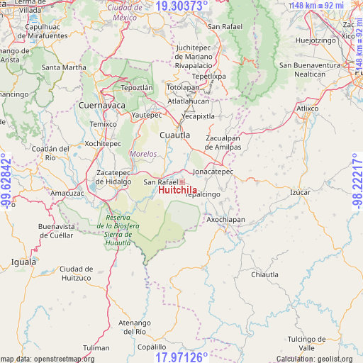
Huitchila GPS coordinates[2]
18° 38' 19.68" North, 98° 55' 31.044" West
| Map corner | latitude | longitude |
|---|---|---|
| Upper-left | 19.30373°, | -99.62842° |
| Center: | 18.6388°, | -98.92529° |
| Lower-right: | 17.97126°, | -98.22217° |
| Map W x H: | 148.2×148.2 km | = 92.1×92.1mi |
| max Lat: | 32.7° ⇑70.9% North |
| Huitchila: | 18.6388° |
| min Lat: | ⇓29.1% South 14.53588° |
| min Long | Huitchila | max Long |
| -117.105° | -98.92529° | -86.73105° |
| W 51.6%⇐ | ⇒48.4% E |
Elevation
Elevation of Huitchila is 1152 m = 3780 ft, and this is 101.7 m = 334 ft below average elevation for this country.
| Max E: |
3497 m = 11473 ft | 56.2% |
| Avg. | 1253.7 m = 4113 ft | |
| Huitchila | 1152 m = 3780 ft | |
Min E: |
-1 m = -3 ft | 43.8% |
See also: Mexico elevation on elevation.city.
Geographical zone
Huitchila is located in North Torrid zone (between Equator and Tropic of Cancer). Distance of this Northern Tropic circle is 533.5 km =331.5 mi to North.| Distance of | km | miles | from Huitchila |
|---|---|---|---|
| North Pole | 7934.6 | 4930.3 | to North |
| Arctic Circle | 5328.7 | 3311.1 | to North |
| Tropic Cancer | 533.5 | 331.5 | to North |
| Equator | 2072.4 | 1287.7 | to South |


Nearby cities:
15 places around Huitchila: (largest is in red/bold)
• Atotonilco
10 km =6.2 mi,  83°
83°
• Chinameca
7.8 km =4.8 mi,  256°
256°
• Constancio Farfán (La Pascuala)
11.9 km =7.4 mi,  345°
345°
• El Salitre
5.4 km =3.4 mi,  320°
320°
• Huitzililla
6.9 km =4.3 mi,  25°
25°
• Ixtlilco el Chico
12.2 km =7.6 mi,  137°
137°
• Moyotepec
11.7 km =7.3 mi, 321°
• San Juan Ahuehueyo
8.5 km =5.3 mi, 354°
• San Rafael Zaragoza
8.3 km =5.2 mi,  272°
272°
• San Vicente de Juárez
8 km =5 mi,  308°
308°
• Tenextepango
10.6 km =6.6 mi,  341°
341°
• Tepalcingo
9.7 km =6 mi,  120°
120°
• Valle de Morelos
11.5 km =7.1 mi, 336°
• Xalostoc
9.7 km =6 mi,  16°
16°
• Zacapalco
3.6 km =2.2 mi, 270°
Sources, notices
• [Note1] Compared only with cities in Mexico existing in our database
• [Src1] Map data: © OpenStreetMap contributors (CC-BY-SA)
• [Src2] Other city data from geonames.org with taken over terms of usage.
• [Src3] Geographical zone / Annual Mean Temperature by Robert A. Rohde @ Wikipedia
