Santo Tomas geodata
Santo Tomas (Hidalgo) is a populated place; located in Mexico in America/Mexico_City (GMT-6) time zone. With population of 2,155 people, there are 4077 cities with bigger population in this country. Compared to other cities in Mexico, 55.1% of cities are located further ↓South; 56.4% of cities are located further ←West and 96.6% of cities have lower elevation than Santo Tomas. Note1


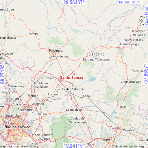
Santo Tomas GPS coordinates[2]
19° 54' 13.104" North, 98° 34' 7.752" West
| Map corner | latitude | longitude |
|---|---|---|
| Upper-left | 20.56337°, | -99.27195° |
| Center: | 19.90364°, | -98.56882° |
| Lower-right: | 19.24115°, | -97.8657° |
| Map W x H: | 147×147 km | = 91.3×91.3mi |
| max Lat: | 32.7° ⇑44.9% North |
| Santo Tomas: | 19.90364° |
| min Lat: | ⇓55.1% South 14.53588° |
| min Long | Santo Tomas | max Long |
| -117.105° | -98.56882° | -86.73105° |
| W 56.4%⇐ | ⇒43.6% E |
Elevation
Elevation of Santo Tomas is 2655 m = 8711 ft, and this is 1401.3 m = 4597 ft above average elevation for this country.
| Max E: |
3497 m = 11473 ft | 3.4% |
| Santo Tomas | 2655 m 8711 ft | |
| Avg. | 1253.7 m = 4113 ft | |
Min E: |
-1 m = -3 ft | 96.6% |
See also: Mexico elevation on elevation.city.
Geographical zone
Santo Tomas is located in North Torrid zone (between Equator and Tropic of Cancer). Distance of this Northern Tropic circle is 392.8 km =244.1 mi to North.| Distance of | km | miles | from Santo Tomas |
|---|---|---|---|
| North Pole | 7794 | 4843 | to North |
| Arctic Circle | 5188.1 | 3223.7 | to North |
| Tropic Cancer | 392.8 | 244.1 | to North |
| Equator | 2213.1 | 1375.2 | to South |


Nearby cities:
15 places around Santo Tomas: (largest is in red/bold)
• Chiconcuac
10.1 km =6.3 mi,  210°
210°
• Ciudad Sahagun
14.3 km =8.9 mi,  182°
182°
• Francisco Villa
4.1 km =2.5 mi,  347°
347°
• Los Cides
12.2 km =7.6 mi,  154°
154°
• San Antonio Ostoyucan
10.5 km =6.5 mi,  286°
286°
• San Gabriel Azteca
5.6 km =3.5 mi,  242°
242°
• San Isidro
12.9 km =8 mi,  190°
190°
• Santa Cruz
13.4 km =8.3 mi,  296°
296°
• Santa María Tecajete
4.8 km =3 mi,  326°
326°
• Santa Mónica
10.5 km =6.5 mi, 328°
• Santiago Tepeyahualco
12.2 km =7.6 mi, 239°
• Singuilucan
8.9 km =5.5 mi,  35°
35°
• Tepeapulco
12.9 km =8 mi,  172°
172°
• Tlanalapa
10.1 km =6.3 mi,  201°
201°
• Zempoala
10.3 km =6.4 mi,  277°
277°
Sources, notices
• [Note1] Compared only with cities in Mexico existing in our database
• [Src1] Map data: © OpenStreetMap contributors (CC-BY-SA)
• [Src2] Other city data from geonames.org with taken over terms of usage.
• [Src3] Geographical zone / Annual Mean Temperature by Robert A. Rohde @ Wikipedia
