Xagacía geodata
Xagacía (Oaxaca) is a seat of a second-order administrative division; located in Mexico in America/Mexico_City (GMT-6) time zone. With population of 1,047 people, there are 8321 cities with bigger population in this country. Compared to other cities in Mexico, 87.1% of cities are located further ↑North; 81% of cities are located further ←West and 56.6% of cities have lower elevation than Xagacía. Note1


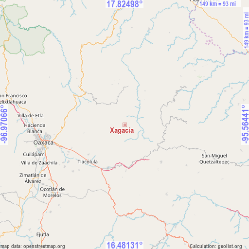
Xagacía GPS coordinates[2]
17° 9' 15.696" North, 96° 16' 3.108" West
| Map corner | latitude | longitude |
|---|---|---|
| Upper-left | 17.82498°, | -96.97066° |
| Center: | 17.15436°, | -96.26753° |
| Lower-right: | 16.48131°, | -95.56441° |
| Map W x H: | 149.4×149.4 km | = 92.8×92.8mi |
| max Lat: | 32.7° ⇑87.1% North |
| Xagacía: | 17.15436° |
| min Lat: | ⇓12.9% South 14.53588° |
| min Long | Xagacía | max Long |
| -117.105° | -96.26753° | -86.73105° |
| W 81%⇐ | ⇒19% E |
Elevation
Elevation of Xagacía is 1640 m = 5381 ft, and this is 386.3 m = 1267 ft above average elevation for this country.
| Max E: |
3497 m = 11473 ft | 43.4% |
| Xagacía | 1640 m 5381 ft | |
| Avg. | 1253.7 m = 4113 ft | |
Min E: |
-1 m = -3 ft | 56.6% |
See also: Mexico elevation on elevation.city.
Geographical zone
Xagacía is located in North Torrid zone (between Equator and Tropic of Cancer). Distance of this Northern Tropic circle is 698.5 km =434 mi to North.| Distance of | km | miles | from Xagacía |
|---|---|---|---|
| North Pole | 8099.7 | 5032.9 | to North |
| Arctic Circle | 5493.8 | 3413.7 | to North |
| Tropic Cancer | 698.5 | 434 | to North |
| Equator | 1907.4 | 1185.2 | to South |


Nearby cities:
15 places around Xagacía: (largest is in red/bold)
• Albarradas
12 km =7.5 mi,  143°
143°
• Cajonos
1.6 km =1 mi,  22°
22°
• Lachicocana
15.1 km =9.4 mi,  132°
132°
• San Andrés Solaga
13.6 km =8.5 mi,  14°
14°
• San Francisco Cajonos
2.6 km =1.6 mi,  44°
44°
• San Mateo Cajonos
6.4 km =4 mi,  82°
82°
• San Melchor Betaza
16.4 km =10.2 mi,  48°
48°
• Santiago Laxopa
8.5 km =5.3 mi,  327°
327°
• Santiago Zoochila
7.8 km =4.8 mi, 20°
• Santo Domingo Yojovi
17.2 km =10.7 mi, 20°
• Villa Hidalgo
10 km =6.2 mi,  70°
70°
• Yaganiza
4.2 km =2.6 mi,  104°
104°
• Yalina
9.5 km =5.9 mi,  3°
3°
• Yatzachi
9.3 km =5.8 mi,  31°
31°
• Zoogocho
9.9 km =6.2 mi, 15°
Sources, notices
• [Note1] Compared only with cities in Mexico existing in our database
• [Src1] Map data: © OpenStreetMap contributors (CC-BY-SA)
• [Src2] Other city data from geonames.org with taken over terms of usage.
• [Src3] Geographical zone / Annual Mean Temperature by Robert A. Rohde @ Wikipedia
