Santiago Zoochila geodata
Santiago Zoochila (Oaxaca) is a seat of a second-order administrative division; located in Mexico in America/Mexico_City (GMT-6) time zone. With population of 374 people, there are 16851 cities with bigger population in this country. Compared to other cities in Mexico, 86.3% of cities are located further ↑North; 81.1% of cities are located further ←West and 52.1% of cities have lower elevation than Santiago Zoochila. Note1


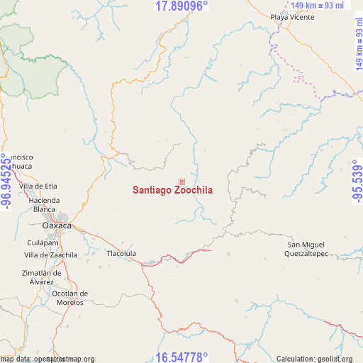
Santiago Zoochila GPS coordinates[2]
17° 13' 14.124" North, 96° 14' 31.632" West
| Map corner | latitude | longitude |
|---|---|---|
| Upper-left | 17.89096°, | -96.94525° |
| Center: | 17.22059°, | -96.24212° |
| Lower-right: | 16.54778°, | -95.539° |
| Map W x H: | 149.3×149.4 km | = 92.8×92.8mi |
| max Lat: | 32.7° ⇑86.3% North |
| Santiago Zoochila: | 17.22059° |
| min Lat: | ⇓13.7% South 14.53588° |
| min Long | Santiago Zoochi | max Long |
| -117.105° | -96.24212° | -86.73105° |
| W 81.1%⇐ | ⇒18.9% E |
Elevation
Elevation of Santiago Zoochila is 1527 m = 5010 ft, and this is 273.3 m = 897 ft above average elevation for this country.
| Max E: |
3497 m = 11473 ft | 47.9% |
| Santiago Zoochila | 1527 m 5010 ft | |
| Avg. | 1253.7 m = 4113 ft | |
Min E: |
-1 m = -3 ft | 52.1% |
See also: Mexico elevation on elevation.city.
Geographical zone
Santiago Zoochila is located in North Torrid zone (between Equator and Tropic of Cancer). Distance of this Northern Tropic circle is 691.2 km =429.5 mi to North.| Distance of | km | miles | from Santiago Zoochila |
|---|---|---|---|
| North Pole | 8092.3 | 5028.3 | to North |
| Arctic Circle | 5486.4 | 3409.1 | to North |
| Tropic Cancer | 691.2 | 429.5 | to North |
| Equator | 1914.8 | 1189.8 | to South |


Nearby cities:
15 places around Santiago Zoochila: (largest is in red/bold)
• Cajonos
6.2 km =3.9 mi,  199°
199°
• San Andrés Solaga
5.8 km =3.6 mi,  6°
6°
• San Andrés Yaá
12.3 km =7.6 mi,  49°
49°
• San Francisco Cajonos
5.6 km =3.5 mi,  188°
188°
• San Juan Tabaá
10.1 km =6.3 mi,  21°
21°
• San Mateo Cajonos
7.5 km =4.7 mi,  150°
150°
• San Melchor Betaza
10.1 km =6.3 mi,  69°
69°
• Santiago Laxopa
7.3 km =4.5 mi,  268°
268°
• Santo Domingo Yojovi
9.4 km =5.8 mi, 21°
• Villa Hidalgo
7.9 km =4.9 mi,  120°
120°
• Xagacía
7.8 km =4.8 mi, 200°
• Yaganiza
8.5 km =5.3 mi,  171°
171°
• Yalina
3 km =1.9 mi,  314°
314°
• Yatzachi
2.3 km =1.4 mi,  75°
75°
• Zoogocho
2.2 km =1.4 mi,  357°
357°
Sources, notices
• [Note1] Compared only with cities in Mexico existing in our database
• [Src1] Map data: © OpenStreetMap contributors (CC-BY-SA)
• [Src2] Other city data from geonames.org with taken over terms of usage.
• [Src3] Geographical zone / Annual Mean Temperature by Robert A. Rohde @ Wikipedia
