San Andrés Yaá geodata
San Andrés Yaá (Oaxaca) is a seat of a second-order administrative division; located in Mexico in America/Mexico_City (GMT-6) time zone. With population of 429 people, there are 16838 cities with bigger population in this country. Compared to other cities in Mexico, 85.4% of cities are located further ↑North; 81.6% of cities are located further ←West and 54% of cities have lower elevation than San Andrés Yaá. Note1


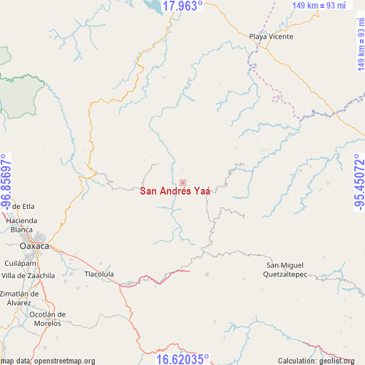
San Andrés Yaá GPS coordinates[2]
17° 17' 34.44" North, 96° 9' 13.824" West
| Map corner | latitude | longitude |
|---|---|---|
| Upper-left | 17.963°, | -96.85697° |
| Center: | 17.2929°, | -96.15384° |
| Lower-right: | 16.62035°, | -95.45072° |
| Map W x H: | 149.3×149.3 km | = 92.8×92.8mi |
| max Lat: | 32.7° ⇑85.4% North |
| San Andrés Yaá: | 17.2929° |
| min Lat: | ⇓14.6% South 14.53588° |
| min Long | San Andrés Ya� | max Long |
| -117.105° | -96.15384° | -86.73105° |
| W 81.6%⇐ | ⇒18.4% E |
Elevation
Elevation of San Andrés Yaá is 1563 m = 5128 ft, and this is 309.3 m = 1015 ft above average elevation for this country.
| Max E: |
3497 m = 11473 ft | 46% |
| San Andrés Yaá | 1563 m 5128 ft | |
| Avg. | 1253.7 m = 4113 ft | |
Min E: |
-1 m = -3 ft | 54% |
See also: Mexico elevation on elevation.city.
Geographical zone
San Andrés Yaá is located in North Torrid zone (between Equator and Tropic of Cancer). Distance of this Northern Tropic circle is 683.1 km =424.5 mi to North.| Distance of | km | miles | from San Andrés Yaá |
|---|---|---|---|
| North Pole | 8084.3 | 5023.3 | to North |
| Arctic Circle | 5478.4 | 3404.1 | to North |
| Tropic Cancer | 683.1 | 424.5 | to North |
| Equator | 1922.8 | 1194.8 | to South |


Nearby cities:
15 places around San Andrés Yaá: (largest is in red/bold)
• San Andrés Solaga
9 km =5.6 mi,  255°
255°
• San Cristóbal Lachirioag
4.9 km =3 mi,  346°
346°
• San Ildefonso Villa Alta
5 km =3.1 mi,  1°
1°
• San Juan Tabaá
5.8 km =3.6 mi,  283°
283°
• San Juan Yatzona
12.2 km =7.6 mi, 352°
• San Melchor Betaza
4.5 km =2.8 mi,  178°
178°
• Santa María Temaxcalapa
9.8 km =6.1 mi,  355°
355°
• Santa María Tiltepec
9 km =5.6 mi,  137°
137°
• Santiago Zoochila
12.3 km =7.6 mi,  229°
229°
• Santo Domingo Roayaga
6.5 km =4 mi,  39°
39°
• Santo Domingo Yojovi
6 km =3.7 mi, 276°
• Villa Hidalgo
12.4 km =7.7 mi,  192°
192°
• Villa Talea de Castro
12.6 km =7.8 mi,  306°
306°
• Yatzachi
10.3 km =6.4 mi,  223°
223°
• Zoogocho
11.1 km =6.9 mi,  238°
238°
Sources, notices
• [Note1] Compared only with cities in Mexico existing in our database
• [Src1] Map data: © OpenStreetMap contributors (CC-BY-SA)
• [Src2] Other city data from geonames.org with taken over terms of usage.
• [Src3] Geographical zone / Annual Mean Temperature by Robert A. Rohde @ Wikipedia
