Santa Cruz Nundaco geodata
Santa Cruz Nundaco (Oaxaca) is a seat of a second-order administrative division; located in Mexico in America/Mexico_City (GMT-6) time zone. With population of 345 people, there are 16860 cities with bigger population in this country. Compared to other cities in Mexico, 86.8% of cities are located further ↑North; 67% of cities are located further ←West and 87% of cities have lower elevation than Santa Cruz Nundaco. Note1


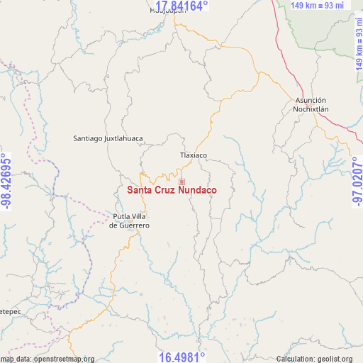
Santa Cruz Nundaco GPS coordinates[2]
17° 10' 15.924" North, 97° 43' 25.752" West
| Map corner | latitude | longitude |
|---|---|---|
| Upper-left | 17.84164°, | -98.42695° |
| Center: | 17.17109°, | -97.72382° |
| Lower-right: | 16.4981°, | -97.0207° |
| Map W x H: | 149.4×149.4 km | = 92.8×92.8mi |
| max Lat: | 32.7° ⇑86.8% North |
| Santa Cruz Nundaco: | 17.17109° |
| min Lat: | ⇓13.2% South 14.53588° |
| min Long | Santa Cruz Nund | max Long |
| -117.105° | -97.72382° | -86.73105° |
| W 67%⇐ | ⇒33% E |
Elevation
Elevation of Santa Cruz Nundaco is 2310 m = 7579 ft, and this is 1056.3 m = 3466 ft above average elevation for this country.
| Max E: |
3497 m = 11473 ft | 13% |
| Santa Cruz Nundaco | 2310 m 7579 ft | |
| Avg. | 1253.7 m = 4113 ft | |
Min E: |
-1 m = -3 ft | 87% |
See also: Mexico elevation on elevation.city.
Geographical zone
Santa Cruz Nundaco is located in North Torrid zone (between Equator and Tropic of Cancer). Distance of this Northern Tropic circle is 696.7 km =432.9 mi to North.| Distance of | km | miles | from Santa Cruz Nundaco |
|---|---|---|---|
| North Pole | 8097.8 | 5031.7 | to North |
| Arctic Circle | 5491.9 | 3412.5 | to North |
| Tropic Cancer | 696.7 | 432.9 | to North |
| Equator | 1909.2 | 1186.3 | to South |


Nearby cities:
15 places around Santa Cruz Nundaco: (largest is in red/bold)
• Barrio San Diego
13.1 km =8.1 mi,  23°
23°
• Colonia Adolfo López Mateos
15 km =9.3 mi, 21°
• Diecinueve de Abril
7.4 km =4.6 mi,  236°
236°
• Heroica Ciudad de Tlaxiaco
11.8 km =7.3 mi, 22°
• La Laguna Guadalupe
13.5 km =8.4 mi,  275°
275°
• La Lobera
10.7 km =6.6 mi, 15°
• Llano de Guadalupe
10.7 km =6.6 mi,  91°
91°
• Los Ángeles
8.3 km =5.2 mi,  263°
263°
• Ojo de Agua
4.3 km =2.7 mi,  158°
158°
• Plan de Guadalupe
8.8 km =5.5 mi,  304°
304°
• San Andrés Chicahuaxtla
12.1 km =7.5 mi, 262°
• San Esteban Atatlahuca
12.5 km =7.8 mi, 157°
• San José Xochixtlán
10.7 km =6.6 mi,  289°
289°
• Santo Domingo del Estado
13.3 km =8.3 mi, 262°
• Yosobee
8.7 km =5.4 mi, 21°
Sources, notices
• [Note1] Compared only with cities in Mexico existing in our database
• [Src1] Map data: © OpenStreetMap contributors (CC-BY-SA)
• [Src2] Other city data from geonames.org with taken over terms of usage.
• [Src3] Geographical zone / Annual Mean Temperature by Robert A. Rohde @ Wikipedia
