San Esteban Atatlahuca geodata
San Esteban Atatlahuca (Oaxaca) is a seat of a second-order administrative division; located in Mexico in America/Mexico_City (GMT-6) time zone. With population of 489 people, there are 16818 cities with bigger population in this country. Compared to other cities in Mexico, 88% of cities are located further ↑North; 67.6% of cities are located further ←West and 92.6% of cities have lower elevation than San Esteban Atatlahuca. Note1


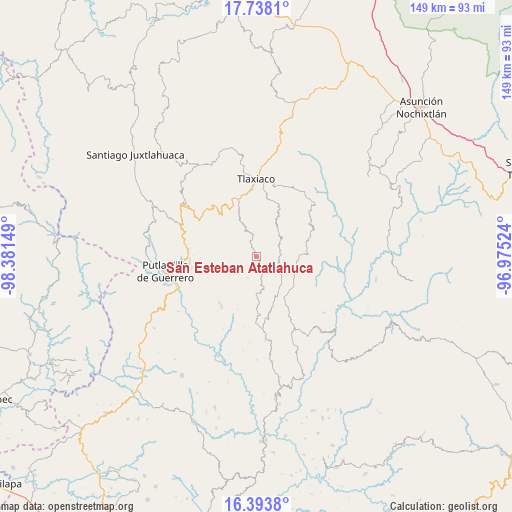
San Esteban Atatlahuca GPS coordinates[2]
17° 4' 1.776" North, 97° 40' 42.096" West
| Map corner | latitude | longitude |
|---|---|---|
| Upper-left | 17.7381°, | -98.38149° |
| Center: | 17.06716°, | -97.67836° |
| Lower-right: | 16.3938°, | -96.97524° |
| Map W x H: | 149.5×149.5 km | = 92.9×92.9mi |
| max Lat: | 32.7° ⇑88% North |
| San Esteban Atatlahuca: | 17.06716° |
| min Lat: | ⇓12% South 14.53588° |
| min Long | San Esteban Ata | max Long |
| -117.105° | -97.67836° | -86.73105° |
| W 67.6%⇐ | ⇒32.4% E |
Elevation
Elevation of San Esteban Atatlahuca is 2511 m = 8238 ft, and this is 1257.3 m = 4125 ft above average elevation for this country.
| Max E: |
3497 m = 11473 ft | 7.4% |
| San Esteban Atatlahuca | 2511 m 8238 ft | |
| Avg. | 1253.7 m = 4113 ft | |
Min E: |
-1 m = -3 ft | 92.6% |
See also: Mexico elevation on elevation.city.
Geographical zone
San Esteban Atatlahuca is located in North Torrid zone (between Equator and Tropic of Cancer). Distance of this Northern Tropic circle is 708.2 km =440.1 mi to North.| Distance of | km | miles | from San Esteban Atatlahuca |
|---|---|---|---|
| North Pole | 8109.4 | 5038.9 | to North |
| Arctic Circle | 5503.5 | 3419.7 | to North |
| Tropic Cancer | 708.2 | 440.1 | to North |
| Equator | 1897.7 | 1179.2 | to South |


Nearby cities:
15 places around San Esteban Atatlahuca: (largest is in red/bold)
• Agua del Toro
9.3 km =5.8 mi,  205°
205°
• Aldama
14.3 km =8.9 mi,  142°
142°
• Chapultepec
14.2 km =8.8 mi,  130°
130°
• Diecinueve de Abril
13.3 km =8.3 mi,  304°
304°
• Ignacio Zaragoza
8.7 km =5.4 mi,  113°
113°
• Llano de Guadalupe
12.7 km =7.9 mi,  27°
27°
• Ojo de Agua
8.2 km =5.1 mi,  336°
336°
• Progreso
11.7 km =7.3 mi,  101°
101°
• San Miguel el Grande Villa Juárez
6.4 km =4 mi, 110°
• Santa Cruz Nundaco
12.5 km =7.8 mi, 337°
• Santa María Ocotlán
12.8 km =8 mi, 205°
• Santa María Yucuhiti
11.1 km =6.9 mi,  240°
240°
• Santiago Nuyoó
11.1 km =6.9 mi, 238°
• Villa Chalcatongo de Hidalgo
12.1 km =7.5 mi, 108°
• Villa de Guadalupe Victoria
7.2 km =4.5 mi,  87°
87°
Sources, notices
• [Note1] Compared only with cities in Mexico existing in our database
• [Src1] Map data: © OpenStreetMap contributors (CC-BY-SA)
• [Src2] Other city data from geonames.org with taken over terms of usage.
• [Src3] Geographical zone / Annual Mean Temperature by Robert A. Rohde @ Wikipedia
