Llano de Guadalupe geodata
Llano de Guadalupe (Oaxaca) is a populated place; located in Mexico in America/Mexico_City (GMT-6) time zone. With population of 574 people, there are 14926 cities with bigger population in this country. Compared to other cities in Mexico, 86.9% of cities are located further ↑North; 68.2% of cities are located further ←West and 91.7% of cities have lower elevation than Llano de Guadalupe. Note1


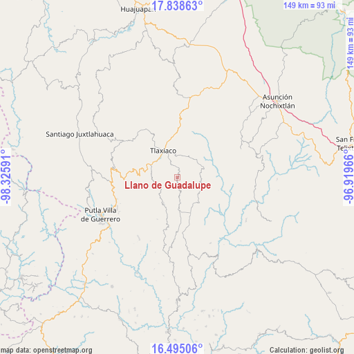
Llano de Guadalupe GPS coordinates[2]
17° 10' 5.016" North, 97° 37' 22.008" West
| Map corner | latitude | longitude |
|---|---|---|
| Upper-left | 17.83863°, | -98.32591° |
| Center: | 17.16806°, | -97.62278° |
| Lower-right: | 16.49506°, | -96.91966° |
| Map W x H: | 149.4×149.4 km | = 92.8×92.8mi |
| max Lat: | 32.7° ⇑86.9% North |
| Llano de Guadalupe: | 17.16806° |
| min Lat: | ⇓13.1% South 14.53588° |
| min Long | Llano de Guadal | max Long |
| -117.105° | -97.62278° | -86.73105° |
| W 68.2%⇐ | ⇒31.8% E |
Elevation
Elevation of Llano de Guadalupe is 2465 m = 8087 ft, and this is 1211.3 m = 3974 ft above average elevation for this country.
| Max E: |
3497 m = 11473 ft | 8.3% |
| Llano de Guadalupe | 2465 m 8087 ft | |
| Avg. | 1253.7 m = 4113 ft | |
Min E: |
-1 m = -3 ft | 91.7% |
See also: Mexico elevation on elevation.city.
Geographical zone
Llano de Guadalupe is located in North Torrid zone (between Equator and Tropic of Cancer). Distance of this Northern Tropic circle is 697 km =433.1 mi to North.| Distance of | km | miles | from Llano de Guadalupe |
|---|---|---|---|
| North Pole | 8098.2 | 5032 | to North |
| Arctic Circle | 5492.3 | 3412.8 | to North |
| Tropic Cancer | 697 | 433.1 | to North |
| Equator | 1908.9 | 1186.1 | to South |


Nearby cities:
15 places around Llano de Guadalupe: (largest is in red/bold)
• Barrio San Diego
13.5 km =8.4 mi,  336°
336°
• Heroica Ciudad de Tlaxiaco
12.8 km =8 mi,  331°
331°
• Ignacio Zaragoza
14.8 km =9.2 mi,  171°
171°
• La Lobera
13.3 km =8.3 mi,  323°
323°
• Ojo de Agua
9.9 km =6.2 mi,  248°
248°
• Progreso
14.7 km =9.1 mi,  157°
157°
• San Cristóbal Amoltepec
14 km =8.7 mi,  22°
22°
• San Esteban Atatlahuca
12.7 km =7.9 mi,  207°
207°
• San Isidro
7.7 km =4.8 mi,  45°
45°
• San Mateo Peñasco
9.7 km =6 mi,  101°
101°
• San Miguel el Grande Villa Juárez
13.5 km =8.4 mi,  179°
179°
• Santa Catarina Ticuá
14.2 km =8.8 mi,  138°
138°
• Santa Cruz Nundaco
10.7 km =6.6 mi,  271°
271°
• Villa de Guadalupe Victoria
11 km =6.8 mi, 173°
• Yosobee
11.3 km =7 mi, 318°
Sources, notices
• [Note1] Compared only with cities in Mexico existing in our database
• [Src1] Map data: © OpenStreetMap contributors (CC-BY-SA)
• [Src2] Other city data from geonames.org with taken over terms of usage.
• [Src3] Geographical zone / Annual Mean Temperature by Robert A. Rohde @ Wikipedia
