San Miguel Acambay geodata
San Miguel Acambay (Hidalgo) is a populated place; located in Mexico in America/Mexico_City (GMT-6) time zone. With population of 932 people, there are 9352 cities with bigger population in this country. Compared to other cities in Mexico, 63.1% of cities are located further ↓South; 50.6% of cities are located further →East and 73.1% of cities have lower elevation than San Miguel Acambay. Note1


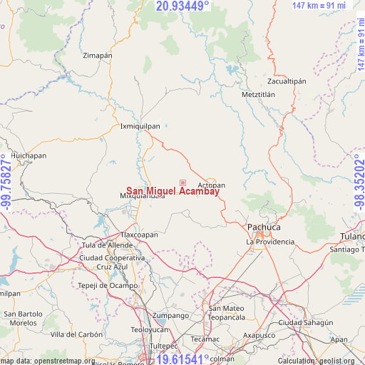
San Miguel Acambay GPS coordinates[2]
20° 16' 34.86" North, 99° 3' 18.504" West
| Map corner | latitude | longitude |
|---|---|---|
| Upper-left | 20.93449°, | -99.75827° |
| Center: | 20.27635°, | -99.05514° |
| Lower-right: | 19.61541°, | -98.35202° |
| Map W x H: | 146.7×146.7 km | = 91.2×91.2mi |
| max Lat: | 32.7° ⇑36.9% North |
| San Miguel Acambay: | 20.27635° |
| min Lat: | ⇓63.1% South 14.53588° |
| min Long | San Miguel Acam | max Long |
| -117.105° | -99.05514° | -86.73105° |
| W 49.4%⇐ | ⇒50.6% E |
Elevation
Elevation of San Miguel Acambay is 1991 m = 6532 ft, and this is 737.3 m = 2419 ft above average elevation for this country.
| Max E: |
3497 m = 11473 ft | 26.9% |
| San Miguel Acambay | 1991 m 6532 ft | |
| Avg. | 1253.7 m = 4113 ft | |
Min E: |
-1 m = -3 ft | 73.1% |
See also: Mexico elevation on elevation.city.
Geographical zone
San Miguel Acambay is located in North Torrid zone (between Equator and Tropic of Cancer). Distance of this Northern Tropic circle is 351.4 km =218.3 mi to North.| Distance of | km | miles | from San Miguel Acambay |
|---|---|---|---|
| North Pole | 7752.5 | 4817.2 | to North |
| Arctic Circle | 5146.7 | 3198 | to North |
| Tropic Cancer | 351.4 | 218.3 | to North |
| Equator | 2254.5 | 1400.9 | to South |


Nearby cities:
15 places around San Miguel Acambay: (largest is in red/bold)
• Arambó
5 km =3.1 mi,  212°
212°
• Bocaja
4.8 km =3 mi,  98°
98°
• Bocamiño
4.2 km =2.6 mi,  203°
203°
• Bominthza
5.9 km =3.7 mi,  53°
53°
• Demacú
4.1 km =2.5 mi,  39°
39°
• El Bondho
5.3 km =3.3 mi,  78°
78°
• El Olvera
3.2 km =2 mi, 102°
• El Rosario
4.4 km =2.7 mi,  135°
135°
• La Comunidad
3.8 km =2.4 mi, 214°
• Pacheco
1.4 km =0.9 mi,  167°
167°
• San José Boxay
5 km =3.1 mi,  251°
251°
• San Salvador
4.4 km =2.7 mi, 76°
• Teofani
5.3 km =3.3 mi,  13°
13°
• Tepatepec
5 km =3.1 mi,  226°
226°
• Vixtha de Madero
1.6 km =1 mi, 100°
Sources, notices
• [Note1] Compared only with cities in Mexico existing in our database
• [Src1] Map data: © OpenStreetMap contributors (CC-BY-SA)
• [Src2] Other city data from geonames.org with taken over terms of usage.
• [Src3] Geographical zone / Annual Mean Temperature by Robert A. Rohde @ Wikipedia
