San Lucas Tlanichico geodata
San Lucas Tlanichico (Oaxaca) is a populated place; located in Mexico in America/Mexico_City (GMT-6) time zone. With population of 530 people, there are 15970 cities with bigger population in this country. Compared to other cities in Mexico, 89.3% of cities are located further ↑North; 77.2% of cities are located further ←West and 55.7% of cities have lower elevation than San Lucas Tlanichico. Note1
Current local time in San Lucas Tlanichico:
08:33 AM, WednesdayDifference from your time zone: hours


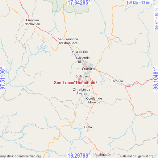
San Lucas Tlanichico GPS coordinates[2]
16° 58' 18.012" North, 96° 48' 28.548" West
| Map corner | latitude | longitude |
|---|---|---|
| Upper-left | 17.64295°, | -97.51106° |
| Center: | 16.97167°, | -96.80793° |
| Lower-right: | 16.29798°, | -96.10481° |
| Map W x H: | 149.5×149.6 km | = 92.9×93mi |
| max Lat: | 32.7° ⇑89.3% North |
| San Lucas Tlanichico: | 16.97167° |
| min Lat: | ⇓10.7% South 14.53588° |
| min Long | San Lucas Tlani | max Long |
| -117.105° | -96.80793° | -86.73105° |
| W 77.2%⇐ | ⇒22.8% E |
Elevation
Elevation of San Lucas Tlanichico is 1609 m = 5279 ft, and this is 355.3 m = 1166 ft above average elevation for this country.
| Max E: |
3497 m = 11473 ft | 44.3% |
| San Lucas Tlanichico | 1609 m 5279 ft | |
| Avg. | 1253.7 m = 4113 ft | |
Min E: |
-1 m = -3 ft | 55.7% |
See also: Mexico elevation on elevation.city.
Geographical zone
San Lucas Tlanichico is located in North Torrid zone (between Equator and Tropic of Cancer). Distance of this Northern Tropic circle is 718.8 km =446.6 mi to North.| Distance of | km | miles | from San Lucas Tlanichico |
|---|---|---|---|
| North Pole | 8120 | 5045.5 | to North |
| Arctic Circle | 5514.1 | 3426.3 | to North |
| Tropic Cancer | 718.8 | 446.6 | to North |
| Equator | 1887.1 | 1172.6 | to South |


Nearby cities:
15 places around San Lucas Tlanichico: (largest is in red/bold)
• Barrio la Guadalupe
6.6 km =4.1 mi,  152°
152°
• Cruz Blanca
7 km =4.3 mi,  45°
45°
• Cuilapan de Guerrero
3 km =1.9 mi,  77°
77°
• El Paraíso
7 km =4.3 mi,  29°
29°
• Fraccionamiento Real del Valle
6.1 km =3.8 mi,  135°
135°
• La Lobera
4 km =2.5 mi,  227°
227°
• Lomas de San Juan
5.8 km =3.6 mi, 50°
• San Antonio Arrazola
7.8 km =4.8 mi,  13°
13°
• San Francisco Javier
7.1 km =4.4 mi, 27°
• San Isidro Monjas
7.1 km =4.4 mi,  62°
62°
• San Miguel Tlanichico
4.9 km =3 mi, 146°
• San Raymundo Jalpam
5.4 km =3.4 mi,  90°
90°
• Santa María Roaló
7.1 km =4.4 mi, 149°
• Trinidad Zaachila
7.3 km =4.5 mi, 140°
• Villa de Zaachila
6.6 km =4.1 mi,  110°
110°
Sources, notices
• [Note1] Compared only with cities in Mexico existing in our database
• [Src1] Map data: © OpenStreetMap contributors (CC-BY-SA)
• [Src2] Other city data from geonames.org with taken over terms of usage.
• [Src3] Geographical zone / Annual Mean Temperature by Robert A. Rohde @ Wikipedia
