Lomas de San Juan geodata
Lomas de San Juan (Oaxaca) is a populated place; located in Mexico in America/Mexico_City (GMT-6) time zone. With population of 901 people, there are 9681 cities with bigger population in this country. Compared to other cities in Mexico, 88.8% of cities are located further ↑North; 77.7% of cities are located further ←West and 54.9% of cities have lower elevation than Lomas de San Juan. Note1


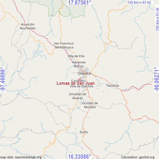
Lomas de San Juan GPS coordinates[2]
17° 0' 15.984" North, 96° 45' 56.988" West
| Map corner | latitude | longitude |
|---|---|---|
| Upper-left | 17.67561°, | -97.46896° |
| Center: | 17.00444°, | -96.76583° |
| Lower-right: | 16.33086°, | -96.06271° |
| Map W x H: | 149.5×149.5 km | = 92.9×92.9mi |
| max Lat: | 32.7° ⇑88.8% North |
| Lomas de San Juan: | 17.00444° |
| min Lat: | ⇓11.2% South 14.53588° |
| min Long | Lomas de San Ju | max Long |
| -117.105° | -96.76583° | -86.73105° |
| W 77.7%⇐ | ⇒22.3% E |
Elevation
Elevation of Lomas de San Juan is 1587 m = 5207 ft, and this is 333.3 m = 1094 ft above average elevation for this country.
| Max E: |
3497 m = 11473 ft | 45.1% |
| Lomas de San Juan | 1587 m 5207 ft | |
| Avg. | 1253.7 m = 4113 ft | |
Min E: |
-1 m = -3 ft | 54.9% |
See also: Mexico elevation on elevation.city.
Geographical zone
Lomas de San Juan is located in North Torrid zone (between Equator and Tropic of Cancer). Distance of this Northern Tropic circle is 715.2 km =444.4 mi to North.| Distance of | km | miles | from Lomas de San Juan |
|---|---|---|---|
| North Pole | 8116.3 | 5043.2 | to North |
| Arctic Circle | 5510.5 | 3424.1 | to North |
| Tropic Cancer | 715.2 | 444.4 | to North |
| Equator | 1890.7 | 1174.8 | to South |


Nearby cities:
15 places around Lomas de San Juan: (largest is in red/bold)
• Animas Trujano
5.8 km =3.6 mi,  105°
105°
• Cruz Blanca
1.4 km =0.9 mi,  24°
24°
• Cuilapan de Guerrero
3.4 km =2.1 mi,  208°
208°
• El Paraíso
2.7 km =1.7 mi,  337°
337°
• Loma Bonita (Paraje Jagüey)
7.1 km =4.4 mi, 339°
• San Agustin de las Juntas
6.1 km =3.8 mi,  90°
90°
• San Agustín de las Juntas
5.8 km =3.6 mi,  81°
81°
• San Antonio Arrazola
4.7 km =2.9 mi,  326°
326°
• San Francisco Javier
3 km =1.9 mi, 335°
• San Isidro Monjas
1.9 km =1.2 mi,  99°
99°
• San Juan Bautista la Raya
4.8 km =3 mi, 114°
• San Lucas Tlanichico
5.8 km =3.6 mi,  230°
230°
• San Raymundo Jalpam
3.8 km =2.4 mi,  165°
165°
• Santa Cruz Xoxocotlán
4.3 km =2.7 mi,  49°
49°
• Villa de Zaachila
6.2 km =3.9 mi,  163°
163°
Sources, notices
• [Note1] Compared only with cities in Mexico existing in our database
• [Src1] Map data: © OpenStreetMap contributors (CC-BY-SA)
• [Src2] Other city data from geonames.org with taken over terms of usage.
• [Src3] Geographical zone / Annual Mean Temperature by Robert A. Rohde @ Wikipedia
