Toltepec geodata
Toltepec (Oaxaca) is a populated place; located in Mexico in America/Mexico_City (GMT-6) time zone. With population of 503 people, there are 16722 cities with bigger population in this country. Compared to other cities in Mexico, 97.6% of cities are located further ↑North; 80% of cities are located further ←West and 71.5% of cities have higher elevation than Toltepec. Note1


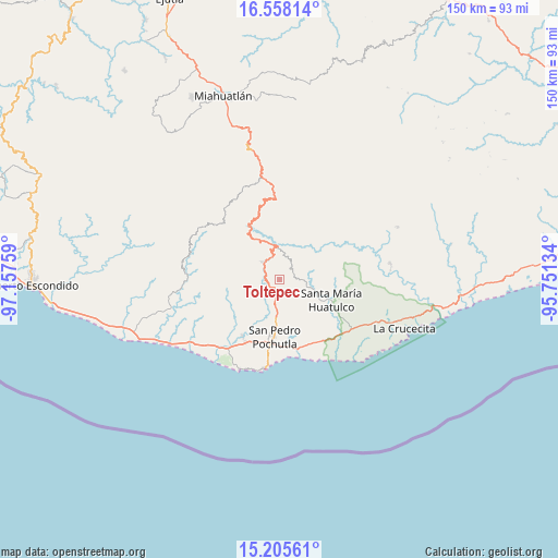
Toltepec GPS coordinates[2]
15° 52' 58.836" North, 96° 27' 16.056" West
| Map corner | latitude | longitude |
|---|---|---|
| Upper-left | 16.55814°, | -97.15759° |
| Center: | 15.88301°, | -96.45446° |
| Lower-right: | 15.20561°, | -95.75134° |
| Map W x H: | 150.4×150.4 km | = 93.5×93.5mi |
| max Lat: | 32.7° ⇑97.6% North |
| Toltepec: | 15.88301° |
| min Lat: | ⇓2.4% South 14.53588° |
| min Long | Toltepec | max Long |
| -117.105° | -96.45446° | -86.73105° |
| W 80%⇐ | ⇒20% E |
Elevation
Elevation of Toltepec is 348 m = 1142 ft, and this is 905.7 m = 2971 ft below average elevation for this country.
| Max E: |
3497 m = 11473 ft | 71.5% |
| Avg. | 1253.7 m = 4113 ft | |
| Toltepec | 348 m = 1142 ft | |
Min E: |
-1 m = -3 ft | 28.5% |
See also: Mexico elevation on elevation.city.
Geographical zone
Toltepec is located in North Torrid zone (between Equator and Tropic of Cancer). Distance of this Northern Tropic circle is 839.9 km =521.9 mi to North.| Distance of | km | miles | from Toltepec |
|---|---|---|---|
| North Pole | 8241 | 5120.7 | to North |
| Arctic Circle | 5635.1 | 3501.5 | to North |
| Tropic Cancer | 839.9 | 521.9 | to North |
| Equator | 1766 | 1097.3 | to South |


Nearby cities:
15 places around Toltepec: (largest is in red/bold)
• Benito Juárez
13.9 km =8.6 mi,  90°
90°
• Buenavista Loxicha
12.9 km =8 mi,  304°
304°
• Candelaria Loxicha
6.3 km =3.9 mi,  319°
319°
• La Erradura
13.9 km =8.6 mi,  113°
113°
• Los Horcones
14.1 km =8.8 mi,  248°
248°
• Los Naranjos Esquipulas
11 km =6.8 mi,  357°
357°
• Pluma Hidalgo
6.2 km =3.9 mi,  38°
38°
• Reyes
8.2 km =5.1 mi,  205°
205°
• San Isidro Apango
13.1 km =8.1 mi,  128°
128°
• San José Chacalapa
6 km =3.7 mi,  189°
189°
• San Miguel Figueroa
12 km =7.5 mi,  153°
153°
• San Pedro Pochutla
15.3 km =9.5 mi,  184°
184°
• San Roque
10.7 km =6.6 mi, 185°
• Santa María Limón
12.8 km =8 mi, 134°
• Santa María Tepejipana
8.4 km =5.2 mi,  290°
290°
Sources, notices
• [Note1] Compared only with cities in Mexico existing in our database
• [Src1] Map data: © OpenStreetMap contributors (CC-BY-SA)
• [Src2] Other city data from geonames.org with taken over terms of usage.
• [Src3] Geographical zone / Annual Mean Temperature by Robert A. Rohde @ Wikipedia
