San Pedro Mixtepec geodata
San Pedro Mixtepec (Oaxaca) is a seat of a second-order administrative division; located in Mexico in America/Mexico_City (GMT-6) time zone. With population of 3,816 people, there are 2395 cities with bigger population in this country. Compared to other cities in Mexico, 95.9% of cities are located further ↑North; 80.9% of cities are located further ←West and 79.6% of cities have lower elevation than San Pedro Mixtepec. Note1


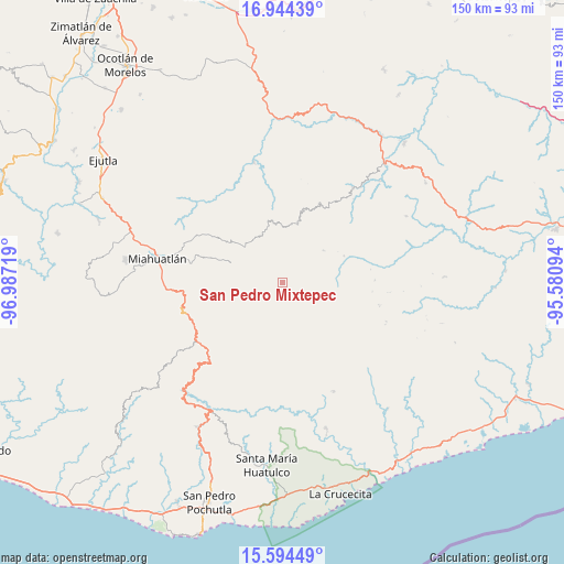
San Pedro Mixtepec GPS coordinates[2]
16° 16' 14.16" North, 96° 17' 2.616" West
| Map corner | latitude | longitude |
|---|---|---|
| Upper-left | 16.94439°, | -96.98719° |
| Center: | 16.2706°, | -96.28406° |
| Lower-right: | 15.59449°, | -95.58094° |
| Map W x H: | 150.1×150.1 km | = 93.3×93.3mi |
| max Lat: | 32.7° ⇑95.9% North |
| San Pedro Mixtepec: | 16.2706° |
| min Lat: | ⇓4.1% South 14.53588° |
| min Long | San Pedro Mixte | max Long |
| -117.105° | -96.28406° | -86.73105° |
| W 80.9%⇐ | ⇒19.1% E |
Elevation
Elevation of San Pedro Mixtepec is 2132 m = 6995 ft, and this is 878.3 m = 2882 ft above average elevation for this country.
| Max E: |
3497 m = 11473 ft | 20.4% |
| San Pedro Mixtepec | 2132 m 6995 ft | |
| Avg. | 1253.7 m = 4113 ft | |
Min E: |
-1 m = -3 ft | 79.6% |
See also: Mexico elevation on elevation.city.
Geographical zone
San Pedro Mixtepec is located in North Torrid zone (between Equator and Tropic of Cancer). Distance of this Northern Tropic circle is 796.8 km =495.1 mi to North.| Distance of | km | miles | from San Pedro Mixtepec |
|---|---|---|---|
| North Pole | 8197.9 | 5093.9 | to North |
| Arctic Circle | 5592.1 | 3474.8 | to North |
| Tropic Cancer | 796.8 | 495.1 | to North |
| Equator | 1809.1 | 1124.1 | to South |


Nearby cities:
15 places around San Pedro Mixtepec: (largest is in red/bold)
• Bramadero
15.8 km =9.8 mi,  325°
325°
• Cieneguilla
14.7 km =9.1 mi,  227°
227°
• La Reforma
12.9 km =8 mi,  254°
254°
• San Cristóbal Amatlán
14.2 km =8.8 mi,  291°
291°
• San Francisco Logueche
13.6 km =8.5 mi,  312°
312°
• San José Lachiguirí
13.1 km =8.1 mi,  335°
335°
• San Juan Mixtepec
1.9 km =1.2 mi, 292°
• San Juan Ozolotepec
15.5 km =9.6 mi,  170°
170°
• Santa Catalina Quieri
6 km =3.7 mi,  18°
18°
• Santa Catalina Quierí
5.8 km =3.6 mi, 18°
• Santa Catarina Quioquitani
4.9 km =3 mi,  356°
356°
• Santiago Lachivía
13.2 km =8.2 mi,  33°
33°
• Santo Domingo Ozolotepec
13.7 km =8.5 mi,  191°
191°
• Santo Tomás Quieri
14 km =8.7 mi,  51°
51°
• Yojuela
13.6 km =8.5 mi,  268°
268°
Sources, notices
• [Note1] Compared only with cities in Mexico existing in our database
• [Src1] Map data: © OpenStreetMap contributors (CC-BY-SA)
• [Src2] Other city data from geonames.org with taken over terms of usage.
• [Src3] Geographical zone / Annual Mean Temperature by Robert A. Rohde @ Wikipedia
