Santo Domingo Ozolotepec geodata
Santo Domingo Ozolotepec (Oaxaca) is a seat of a second-order administrative division; located in Mexico in America/Mexico_City (GMT-6) time zone. With population of 834 people, there are 10487 cities with bigger population in this country. Compared to other cities in Mexico, 96.6% of cities are located further ↑North; 80.8% of cities are located further ←West and 87.1% of cities have lower elevation than Santo Domingo Ozolotepec. Note1
Current local time in Santo Domingo Ozolotepec:
12:31 PM, MondayDifference from your time zone: hours


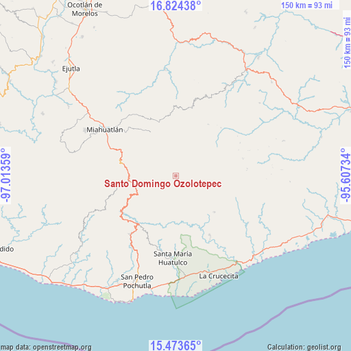
Santo Domingo Ozolotepec GPS coordinates[2]
16° 9' 0.612" North, 96° 18' 37.656" West
| Map corner | latitude | longitude |
|---|---|---|
| Upper-left | 16.82438°, | -97.01359° |
| Center: | 16.15017°, | -96.31046° |
| Lower-right: | 15.47365°, | -95.60734° |
| Map W x H: | 150.2×150.2 km | = 93.3×93.3mi |
| max Lat: | 32.7° ⇑96.6% North |
| Santo Domingo Ozolotepec: | 16.15017° |
| min Lat: | ⇓3.4% South 14.53588° |
| min Long | Santo Domingo O | max Long |
| -117.105° | -96.31046° | -86.73105° |
| W 80.8%⇐ | ⇒19.2% E |
Elevation
Elevation of Santo Domingo Ozolotepec is 2313 m = 7589 ft, and this is 1059.3 m = 3475 ft above average elevation for this country.
| Max E: |
3497 m = 11473 ft | 12.9% |
| Santo Domingo Ozolotepec | 2313 m 7589 ft | |
| Avg. | 1253.7 m = 4113 ft | |
Min E: |
-1 m = -3 ft | 87.1% |
See also: Mexico elevation on elevation.city.
Geographical zone
Santo Domingo Ozolotepec is located in North Torrid zone (between Equator and Tropic of Cancer). Distance of this Northern Tropic circle is 810.2 km =503.4 mi to North.| Distance of | km | miles | from Santo Domingo Ozolotepec |
|---|---|---|---|
| North Pole | 8211.3 | 5102.3 | to North |
| Arctic Circle | 5605.4 | 3483 | to North |
| Tropic Cancer | 810.2 | 503.4 | to North |
| Equator | 1795.7 | 1115.8 | to South |


Nearby cities:
15 places around Santo Domingo Ozolotepec: (largest is in red/bold)
• Cieneguilla
8.8 km =5.5 mi,  293°
293°
• La Reforma
13.8 km =8.6 mi,  315°
315°
• San Andrés Lovene
16.8 km =10.4 mi,  137°
137°
• San Francisco Ozolotepec
10.9 km =6.8 mi,  120°
120°
• San Gregorio Ozolotepec
2.9 km =1.8 mi,  224°
224°
• San Juan Guivini
13.6 km =8.5 mi,  114°
114°
• San Juan Mixtepec
14.2 km =8.8 mi,  4°
4°
• San Juan Ozolotepec
5.8 km =3.6 mi, 109°
• San Marcial Ozolotepec
12.2 km =7.6 mi,  236°
236°
• San Mateo Piñas
16.8 km =10.4 mi,  188°
188°
• San Mateo Río Hondo
14.5 km =9 mi,  267°
267°
• San Pedro Mixtepec
13.7 km =8.5 mi,  11°
11°
• Santa Cruz Ozolotepec
8.9 km =5.5 mi,  174°
174°
• Santa María Ozolotepec
6.7 km =4.2 mi,  253°
253°
• Santiago Lapaguía
12.8 km =8 mi,  97°
97°
Sources, notices
• [Note1] Compared only with cities in Mexico existing in our database
• [Src1] Map data: © OpenStreetMap contributors (CC-BY-SA)
• [Src2] Other city data from geonames.org with taken over terms of usage.
• [Src3] Geographical zone / Annual Mean Temperature by Robert A. Rohde @ Wikipedia
