San Pedro Apóstol geodata
San Pedro Apóstol (Oaxaca) is a seat of a second-order administrative division; located in Mexico in America/Mexico_City (GMT-6) time zone. With population of 1,447 people, there are 5963 cities with bigger population in this country. Compared to other cities in Mexico, 92.4% of cities are located further ↑North; 78.1% of cities are located further ←West and 51.2% of cities have lower elevation than San Pedro Apóstol. Note1


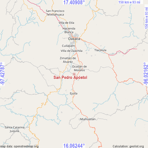
San Pedro Apóstol GPS coordinates[2]
16° 44' 13.02" North, 96° 43' 29.064" West
| Map corner | latitude | longitude |
|---|---|---|
| Upper-left | 17.40908°, | -97.42787° |
| Center: | 16.73695°, | -96.72474° |
| Lower-right: | 16.06244°, | -96.02162° |
| Map W x H: | 149.7×149.7 km | = 93×93mi |
| max Lat: | 32.7° ⇑92.4% North |
| San Pedro Apóstol: | 16.73695° |
| min Lat: | ⇓7.6% South 14.53588° |
| min Long | San Pedro Após | max Long |
| -117.105° | -96.72474° | -86.73105° |
| W 78.1%⇐ | ⇒21.9% E |
Elevation
Elevation of San Pedro Apóstol is 1494 m = 4902 ft, and this is 240.3 m = 788 ft above average elevation for this country.
| Max E: |
3497 m = 11473 ft | 48.8% |
| San Pedro Apóstol | 1494 m 4902 ft | |
| Avg. | 1253.7 m = 4113 ft | |
Min E: |
-1 m = -3 ft | 51.2% |
See also: Mexico elevation on elevation.city.
Geographical zone
San Pedro Apóstol is located in North Torrid zone (between Equator and Tropic of Cancer). Distance of this Northern Tropic circle is 744.9 km =462.9 mi to North.| Distance of | km | miles | from San Pedro Apóstol |
|---|---|---|---|
| North Pole | 8146.1 | 5061.8 | to North |
| Arctic Circle | 5540.2 | 3442.5 | to North |
| Tropic Cancer | 744.9 | 462.9 | to North |
| Equator | 1861 | 1156.4 | to South |


Nearby cities:
15 places around San Pedro Apóstol: (largest is in red/bold)
• Asunción Ocotlán
2.8 km =1.7 mi,  7°
7°
• Magdalena Ocotlán
3.5 km =2.2 mi,  153°
153°
• Monte del Toro
6.8 km =4.2 mi,  193°
193°
• Ocotlán de Morelos
8.1 km =5 mi,  41°
41°
• Praxedis de Guerrero
9.2 km =5.7 mi,  101°
101°
• San Antonino Castillo Velasco
8.4 km =5.2 mi,  31°
31°
• San Dionisio Ocotlán
4.9 km =3 mi,  76°
76°
• San José Guelatová de Díaz
8.7 km =5.4 mi,  312°
312°
• San José del Progreso
7 km =4.3 mi,  142°
142°
• San Martín de los Canseco
8.9 km =5.5 mi,  182°
182°
• San Pedro Martir
1.6 km =1 mi,  64°
64°
• Santa Inés Yatzeche
8.5 km =5.3 mi,  335°
335°
• Santa Lucía Ocotlán
4.8 km =3 mi,  88°
88°
• Santiago Apostol
7.4 km =4.6 mi,  3°
3°
• Tejas de Morelos
5.3 km =3.3 mi,  298°
298°
Sources, notices
• [Note1] Compared only with cities in Mexico existing in our database
• [Src1] Map data: © OpenStreetMap contributors (CC-BY-SA)
• [Src2] Other city data from geonames.org with taken over terms of usage.
• [Src3] Geographical zone / Annual Mean Temperature by Robert A. Rohde @ Wikipedia
