Santa Inés Yatzeche geodata
Santa Inés Yatzeche (Oaxaca) is a seat of a second-order administrative division; located in Mexico in America/Mexico_City (GMT-6) time zone. With population of 921 people, there are 9483 cities with bigger population in this country. Compared to other cities in Mexico, 91.6% of cities are located further ↑North; 77.8% of cities are located further ←West and 50.8% of cities have lower elevation than Santa Inés Yatzeche. Note1


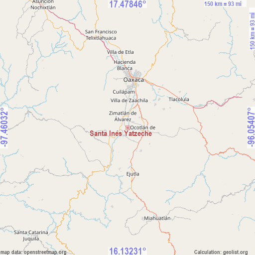
Santa Inés Yatzeche GPS coordinates[2]
16° 48' 23.688" North, 96° 45' 25.884" West
| Map corner | latitude | longitude |
|---|---|---|
| Upper-left | 17.47846°, | -97.46032° |
| Center: | 16.80658°, | -96.75719° |
| Lower-right: | 16.13231°, | -96.05407° |
| Map W x H: | 149.7×149.7 km | = 93×93mi |
| max Lat: | 32.7° ⇑91.6% North |
| Santa Inés Yatzeche: | 16.80658° |
| min Lat: | ⇓8.4% South 14.53588° |
| min Long | Santa Inés Yat | max Long |
| -117.105° | -96.75719° | -86.73105° |
| W 77.8%⇐ | ⇒22.2% E |
Elevation
Elevation of Santa Inés Yatzeche is 1475 m = 4839 ft, and this is 221.3 m = 726 ft above average elevation for this country.
| Max E: |
3497 m = 11473 ft | 49.2% |
| Santa Inés Yatzeche | 1475 m 4839 ft | |
| Avg. | 1253.7 m = 4113 ft | |
Min E: |
-1 m = -3 ft | 50.8% |
See also: Mexico elevation on elevation.city.
Geographical zone
Santa Inés Yatzeche is located in North Torrid zone (between Equator and Tropic of Cancer). Distance of this Northern Tropic circle is 737.2 km =458.1 mi to North.| Distance of | km | miles | from Santa Inés Yatzeche |
|---|---|---|---|
| North Pole | 8138.3 | 5056.9 | to North |
| Arctic Circle | 5532.5 | 3437.7 | to North |
| Tropic Cancer | 737.2 | 458.1 | to North |
| Equator | 1868.7 | 1161.2 | to South |


Nearby cities:
15 places around Santa Inés Yatzeche: (largest is in red/bold)
• Asunción Ocotlán
6.3 km =3.9 mi,  142°
142°
• San Antonino Castillo Velasco
7.9 km =4.9 mi,  94°
94°
• San Jerónimo Zegache
5 km =3.1 mi,  8°
8°
• San José Guelatová de Díaz
3.5 km =2.2 mi,  236°
236°
• San Nicolás Quialana
4.7 km =2.9 mi,  330°
330°
• San Pablo Huixtepec
2.9 km =1.8 mi,  299°
299°
• San Pedro Apóstol
8.5 km =5.3 mi,  155°
155°
• Santa Ana Zegache
4.5 km =2.8 mi,  41°
41°
• Santa Catarina Quiané
8.6 km =5.3 mi, 11°
• Santa Gertrudis
5.1 km =3.2 mi, 243°
• Santa María Vigallo
8.5 km =5.3 mi,  311°
311°
• Santiago Apostol
3.9 km =2.4 mi, 94°
• Tejas de Morelos
5.4 km =3.4 mi,  193°
193°
• Valdeflores
8.5 km =5.3 mi, 237°
• Zimatlán de Álvarez
7.6 km =4.7 mi,  337°
337°
Sources, notices
• [Note1] Compared only with cities in Mexico existing in our database
• [Src1] Map data: © OpenStreetMap contributors (CC-BY-SA)
• [Src2] Other city data from geonames.org with taken over terms of usage.
• [Src3] Geographical zone / Annual Mean Temperature by Robert A. Rohde @ Wikipedia
