San José Buena Vista geodata
San José Buena Vista (Puebla) is a populated place; located in Mexico in America/Mexico_City (GMT-6) time zone. With population of 1,073 people, there are 8130 cities with bigger population in this country. Compared to other cities in Mexico, 73.7% of cities are located further ↑North; 71.8% of cities are located further ←West and 53% of cities have higher elevation than San José Buena Vista. Note1


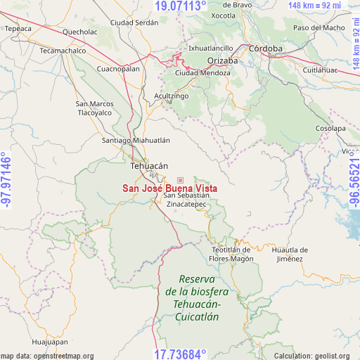
San José Buena Vista GPS coordinates[2]
18° 24' 19.008" North, 97° 16' 5.988" West
| Map corner | latitude | longitude |
|---|---|---|
| Upper-left | 19.07113°, | -97.97146° |
| Center: | 18.40528°, | -97.26833° |
| Lower-right: | 17.73684°, | -96.56521° |
| Map W x H: | 148.4×148.4 km | = 92.2×92.2mi |
| max Lat: | 32.7° ⇑73.7% North |
| San José Buena Vista: | 18.40528° |
| min Lat: | ⇓26.3% South 14.53588° |
| min Long | San José Buena | max Long |
| -117.105° | -97.26833° | -86.73105° |
| W 71.8%⇐ | ⇒28.2% E |
Elevation
Elevation of San José Buena Vista is 1289 m = 4229 ft, and this is 35.3 m = 116 ft above average elevation for this country.
| Max E: |
3497 m = 11473 ft | 53% |
| San José Buena Vista | 1289 m 4229 ft | |
| Avg. | 1253.7 m = 4113 ft | |
Min E: |
-1 m = -3 ft | 47% |
See also: Mexico elevation on elevation.city.
Geographical zone
San José Buena Vista is located in North Torrid zone (between Equator and Tropic of Cancer). Distance of this Northern Tropic circle is 559.4 km =347.6 mi to North.| Distance of | km | miles | from San José Buena Vista |
|---|---|---|---|
| North Pole | 7960.6 | 4946.5 | to North |
| Arctic Circle | 5354.7 | 3327.3 | to North |
| Tropic Cancer | 559.4 | 347.6 | to North |
| Equator | 2046.5 | 1271.6 | to South |


Nearby cities:
15 places around San José Buena Vista: (largest is in red/bold)
• Ajalpan
3.1 km =1.9 mi,  160°
160°
• Altepexi
5.1 km =3.2 mi,  220°
220°
• Cinco de Mayo
0.8 km =0.5 mi,  0°
0°
• Miahuatlán
12.8 km =8 mi,  189°
189°
• Necoxcalco
6.9 km =4.3 mi,  332°
332°
• Necoxtla
9.7 km =6 mi,  265°
265°
• San Antonio Cañada
12.6 km =7.8 mi,  347°
347°
• San Gabriel Chilac
12.1 km =7.5 mi, 223°
• San Jerónimo Axochitlán
14.1 km =8.8 mi,  177°
177°
• San Mateo Tlacoxcalco
14.6 km =9.1 mi,  204°
204°
• San Miguel
6.6 km =4.1 mi,  277°
277°
• Santa Cruz Acapa
6.1 km =3.8 mi, 270°
• Telpatlán
15.1 km =9.4 mi,  54°
54°
• Tepetzingo
7.6 km =4.7 mi, 284°
• Zinacatepec
8.1 km =5 mi, 163°
Sources, notices
• [Note1] Compared only with cities in Mexico existing in our database
• [Src1] Map data: © OpenStreetMap contributors (CC-BY-SA)
• [Src2] Other city data from geonames.org with taken over terms of usage.
• [Src3] Geographical zone / Annual Mean Temperature by Robert A. Rohde @ Wikipedia
