Ajalpan geodata
Ajalpan (Puebla) is a seat of a second-order administrative division; located in Mexico in America/Mexico_City (GMT-6) time zone. With population of 28,031 people, there are 355 cities with bigger population in this country. Compared to other cities in Mexico, 74.1% of cities are located further ↑North; 71.9% of cities are located further ←West and 54.4% of cities have higher elevation than Ajalpan. Note1


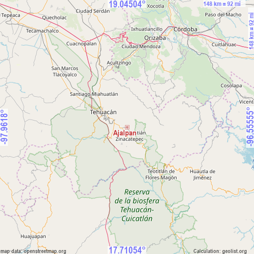
Ajalpan GPS coordinates[2]
18° 22' 44.688" North, 97° 15' 31.212" West
| Map corner | latitude | longitude |
|---|---|---|
| Upper-left | 19.04504°, | -97.9618° |
| Center: | 18.37908°, | -97.25867° |
| Lower-right: | 17.71054°, | -96.55555° |
| Map W x H: | 148.4×148.4 km | = 92.2×92.2mi |
| max Lat: | 32.7° ⇑74.1% North |
| Ajalpan: | 18.37908° |
| min Lat: | ⇓25.9% South 14.53588° |
| min Long | Ajalpan | max Long |
| -117.105° | -97.25867° | -86.73105° |
| W 71.9%⇐ | ⇒28.1% E |
Elevation
Elevation of Ajalpan is 1223 m = 4012 ft, and this is 30.7 m = 101 ft below average elevation for this country.
| Max E: |
3497 m = 11473 ft | 54.4% |
| Avg. | 1253.7 m = 4113 ft | |
| Ajalpan | 1223 m = 4012 ft | |
Min E: |
-1 m = -3 ft | 45.6% |
See also: Mexico elevation on elevation.city.
Geographical zone
Ajalpan is located in North Torrid zone (between Equator and Tropic of Cancer). Distance of this Northern Tropic circle is 562.4 km =349.5 mi to North.| Distance of | km | miles | from Ajalpan |
|---|---|---|---|
| North Pole | 7963.5 | 4948.3 | to North |
| Arctic Circle | 5357.6 | 3329.1 | to North |
| Tropic Cancer | 562.4 | 349.5 | to North |
| Equator | 2043.6 | 1269.8 | to South |


Nearby cities:
15 places around Ajalpan: (largest is in red/bold)
• Altepexi
4.4 km =2.7 mi,  257°
257°
• Calipan
13.7 km =8.5 mi,  132°
132°
• Cinco de Mayo
3.8 km =2.4 mi,  344°
344°
• Miahuatlán
10.2 km =6.3 mi,  197°
197°
• Necoxcalco
10 km =6.2 mi, 335°
• Necoxtla
10.9 km =6.8 mi,  281°
281°
• San Gabriel Chilac
11 km =6.8 mi,  237°
237°
• San Jerónimo Axochitlán
11.2 km =7 mi,  182°
182°
• San José Buena Vista
3.1 km =1.9 mi, 340°
• San Mateo Tlacoxcalco
12.6 km =7.8 mi,  214°
214°
• San Miguel
8.4 km =5.2 mi,  296°
296°
• San Pedro Tetitlán
14.9 km =9.3 mi, 207°
• Santa Cruz Acapa
7.7 km =4.8 mi,  292°
292°
• Tepetzingo
9.6 km =6 mi, 299°
• Zinacatepec
5.1 km =3.2 mi,  164°
164°
Sources, notices
• [Note1] Compared only with cities in Mexico existing in our database
• [Src1] Map data: © OpenStreetMap contributors (CC-BY-SA)
• [Src2] Other city data from geonames.org with taken over terms of usage.
• [Src3] Geographical zone / Annual Mean Temperature by Robert A. Rohde @ Wikipedia
