San Pablo geodata
San Pablo (Veracruz) is a populated place; located in Mexico in America/Mexico_City (GMT-6) time zone. With population of 916 people, there are 9527 cities with bigger population in this country. Compared to other cities in Mexico, 67% of cities are located further ↓South; 72.6% of cities are located further ←West and 86.1% of cities have higher elevation than San Pablo. Note1


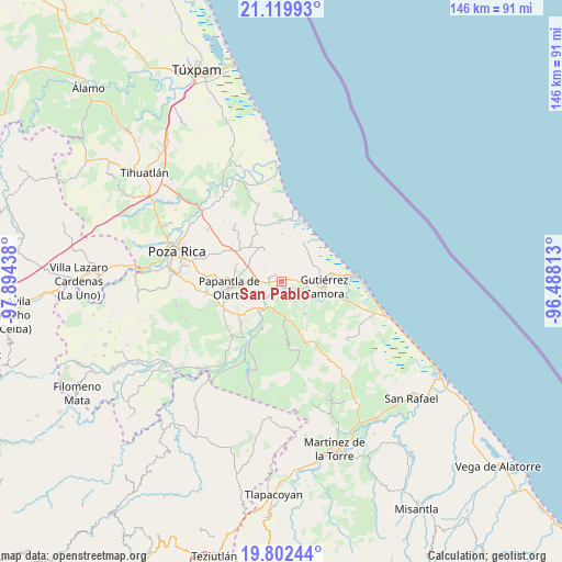
San Pablo GPS coordinates[2]
20° 27' 45.36" North, 97° 11' 28.5" West
| Map corner | latitude | longitude |
|---|---|---|
| Upper-left | 21.11993°, | -97.89438° |
| Center: | 20.4626°, | -97.19125° |
| Lower-right: | 19.80244°, | -96.48813° |
| Map W x H: | 146.5×146.5 km | = 91×91mi |
| max Lat: | 32.7° ⇑33% North |
| San Pablo: | 20.4626° |
| min Lat: | ⇓67% South 14.53588° |
| min Long | San Pablo | max Long |
| -117.105° | -97.19125° | -86.73105° |
| W 72.6%⇐ | ⇒27.4% E |
Elevation
Elevation of San Pablo is 38 m = 125 ft, and this is 1215.7 m = 3989 ft below average elevation for this country.
| Max E: |
3497 m = 11473 ft | 86.1% |
| Avg. | 1253.7 m = 4113 ft | |
| San Pablo | 38 m = 125 ft | |
Min E: |
-1 m = -3 ft | 13.9% |
See also: Mexico elevation on elevation.city.
Geographical zone
San Pablo is located in North Torrid zone (between Equator and Tropic of Cancer). Distance of this Northern Tropic circle is 330.7 km =205.5 mi to North.| Distance of | km | miles | from San Pablo |
|---|---|---|---|
| North Pole | 7731.8 | 4804.3 | to North |
| Arctic Circle | 5125.9 | 3185.1 | to North |
| Tropic Cancer | 330.7 | 205.5 | to North |
| Equator | 2275.2 | 1413.7 | to South |


Nearby cities:
15 places around San Pablo: (largest is in red/bold)
• Anclón y Arenal
8.4 km =5.2 mi,  111°
111°
• Carrillo Puerto
5 km =3.1 mi,  165°
165°
• El Cedro
2.4 km =1.5 mi,  315°
315°
• El Palmar
5.8 km =3.6 mi,  254°
254°
• El Remolino
8.4 km =5.2 mi,  194°
194°
• Emiliano Zapata
9.2 km =5.7 mi,  175°
175°
• Gutiérrez Zamora
11 km =6.8 mi,  95°
95°
• Hermenegildo Galeana
3.8 km =2.4 mi,  86°
86°
• Ignacio M. Altamirano (Plan de Altamirano)
10.4 km =6.5 mi,  143°
143°
• La Concha
10.7 km =6.6 mi,  279°
279°
• La Guásima
10.5 km =6.5 mi, 324°
• Lomas de Arena
6.7 km =4.2 mi,  151°
151°
• Polutla
10.1 km =6.3 mi, 315°
• Rafael Valenzuela
9.2 km =5.7 mi,  133°
133°
• Totomoxtle
6.8 km =4.2 mi,  273°
273°
Sources, notices
• [Note1] Compared only with cities in Mexico existing in our database
• [Src1] Map data: © OpenStreetMap contributors (CC-BY-SA)
• [Src2] Other city data from geonames.org with taken over terms of usage.
• [Src3] Geographical zone / Annual Mean Temperature by Robert A. Rohde @ Wikipedia
