El Cedro geodata
El Cedro (Veracruz) is a populated place; located in Mexico in America/Mexico_City (GMT-6) time zone. With population of 739 people, there are 11825 cities with bigger population in this country. Compared to other cities in Mexico, 67.3% of cities are located further ↓South; 72.4% of cities are located further ←West and 79.5% of cities have higher elevation than El Cedro. Note1


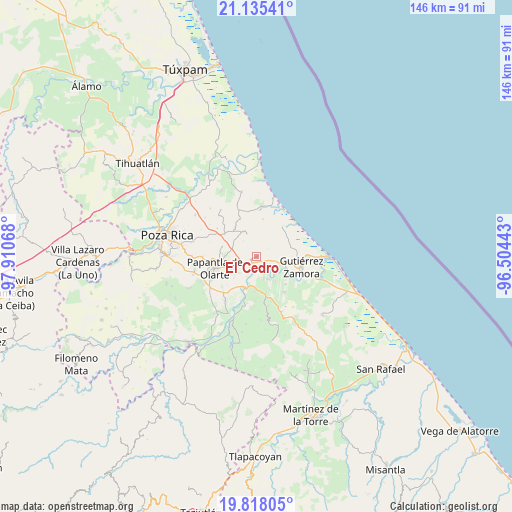
El Cedro GPS coordinates[2]
20° 28' 41.304" North, 97° 12' 27.18" West
| Map corner | latitude | longitude |
|---|---|---|
| Upper-left | 21.13541°, | -97.91068° |
| Center: | 20.47814°, | -97.20755° |
| Lower-right: | 19.81805°, | -96.50443° |
| Map W x H: | 146.5×146.5 km | = 91×91mi |
| max Lat: | 32.7° ⇑32.7% North |
| El Cedro: | 20.47814° |
| min Lat: | ⇓67.3% South 14.53588° |
| min Long | El Cedro | max Long |
| -117.105° | -97.20755° | -86.73105° |
| W 72.4%⇐ | ⇒27.6% E |
Elevation
Elevation of El Cedro is 102 m = 335 ft, and this is 1151.7 m = 3779 ft below average elevation for this country.
| Max E: |
3497 m = 11473 ft | 79.5% |
| Avg. | 1253.7 m = 4113 ft | |
| El Cedro | 102 m = 335 ft | |
Min E: |
-1 m = -3 ft | 20.5% |
See also: Mexico elevation on elevation.city.
Geographical zone
El Cedro is located in North Torrid zone (between Equator and Tropic of Cancer). Distance of this Northern Tropic circle is 329 km =204.4 mi to North.| Distance of | km | miles | from El Cedro |
|---|---|---|---|
| North Pole | 7730.1 | 4803.3 | to North |
| Arctic Circle | 5124.2 | 3184 | to North |
| Tropic Cancer | 329 | 204.4 | to North |
| Equator | 2277 | 1414.9 | to South |


Nearby cities:
15 places around El Cedro: (largest is in red/bold)
• Anclón y Arenal
10.6 km =6.6 mi,  116°
116°
• Boca de Lima
11.4 km =7.1 mi,  40°
40°
• Carrillo Puerto
7.2 km =4.5 mi,  155°
155°
• El Palmar
5.1 km =3.2 mi,  229°
229°
• El Remolino
9.9 km =6.2 mi,  182°
182°
• Emiliano Zapata
11.2 km =7 mi,  167°
167°
• Hermenegildo Galeana
5.7 km =3.5 mi,  105°
105°
• La Concha
8.9 km =5.5 mi,  270°
270°
• La Guásima
8.1 km =5 mi,  327°
327°
• Lomas de Arena
9 km =5.6 mi,  147°
147°
• Polutla
7.7 km =4.8 mi,  316°
316°
• Rafael Valenzuela
11.6 km =7.2 mi,  134°
134°
• San Pablo
2.4 km =1.5 mi,  135°
135°
• Tenixtepec
10.8 km =6.7 mi,  9°
9°
• Totomoxtle
5.3 km =3.3 mi,  255°
255°
Sources, notices
• [Note1] Compared only with cities in Mexico existing in our database
• [Src1] Map data: © OpenStreetMap contributors (CC-BY-SA)
• [Src2] Other city data from geonames.org with taken over terms of usage.
• [Src3] Geographical zone / Annual Mean Temperature by Robert A. Rohde @ Wikipedia
