La Guásima geodata
La Guásima (Veracruz) is a populated place; located in Mexico in America/Mexico_City (GMT-6) time zone. With population of 1,002 people, there are 8703 cities with bigger population in this country. Compared to other cities in Mexico, 68.7% of cities are located further ↓South; 72% of cities are located further ←West and 82.9% of cities have higher elevation than La Guásima. Note1


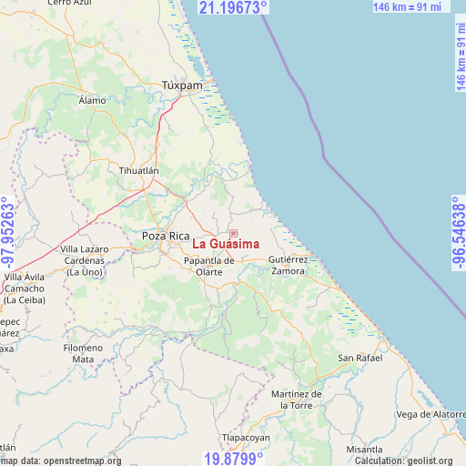
La Guásima GPS coordinates[2]
20° 32' 23.028" North, 97° 14' 58.2" West
| Map corner | latitude | longitude |
|---|---|---|
| Upper-left | 21.19673°, | -97.95263° |
| Center: | 20.53973°, | -97.2495° |
| Lower-right: | 19.8799°, | -96.54638° |
| Map W x H: | 146.4×146.4 km | = 91×91mi |
| max Lat: | 32.7° ⇑31.3% North |
| La Guásima: | 20.53973° |
| min Lat: | ⇓68.7% South 14.53588° |
| min Long | La Guásima | max Long |
| -117.105° | -97.2495° | -86.73105° |
| W 72%⇐ | ⇒28% E |
Elevation
Elevation of La Guásima is 61 m = 200 ft, and this is 1192.7 m = 3913 ft below average elevation for this country.
| Max E: |
3497 m = 11473 ft | 82.9% |
| Avg. | 1253.7 m = 4113 ft | |
| La Guásima | 61 m = 200 ft | |
Min E: |
-1 m = -3 ft | 17.1% |
See also: Mexico elevation on elevation.city.
Geographical zone
La Guásima is located in North Torrid zone (between Equator and Tropic of Cancer). Distance of this Northern Tropic circle is 322.1 km =200.1 mi to North.| Distance of | km | miles | from La Guásima |
|---|---|---|---|
| North Pole | 7723.3 | 4799 | to North |
| Arctic Circle | 5117.4 | 3179.8 | to North |
| Tropic Cancer | 322.1 | 200.1 | to North |
| Equator | 2283.8 | 1419.1 | to South |


Nearby cities:
15 places around La Guásima: (largest is in red/bold)
• Adolfo Ruíz Cortines
8.6 km =5.3 mi,  316°
316°
• Carrizal
6.2 km =3.9 mi,  353°
353°
• El Cedro
8.1 km =5 mi,  147°
147°
• El Palmar
10.2 km =6.3 mi,  177°
177°
• La Concha
8.1 km =5 mi,  213°
213°
• Plan de los Mangos
9.3 km =5.8 mi,  284°
284°
• Polutla
1.6 km =1 mi,  216°
216°
• Poza Verde
3.7 km =2.3 mi, 354°
• Puente de Piedra
9.2 km =5.7 mi,  37°
37°
• San Pablo
10.5 km =6.5 mi,  144°
144°
• Santa Águeda
7 km =4.3 mi, 279°
• Sombrerete
11.2 km =7 mi,  307°
307°
• Tenixtepec
7.2 km =4.5 mi,  58°
58°
• Totomoxtle
8.2 km =5.1 mi,  185°
185°
• Vicente Herrera
11.2 km =7 mi,  291°
291°
Sources, notices
• [Note1] Compared only with cities in Mexico existing in our database
• [Src1] Map data: © OpenStreetMap contributors (CC-BY-SA)
• [Src2] Other city data from geonames.org with taken over terms of usage.
• [Src3] Geographical zone / Annual Mean Temperature by Robert A. Rohde @ Wikipedia
