El Palmar geodata
El Palmar (Veracruz) is a populated place; located in Mexico in America/Mexico_City (GMT-6) time zone. With population of 587 people, there are 14622 cities with bigger population in this country. Compared to other cities in Mexico, 66.7% of cities are located further ↓South; 72% of cities are located further ←West and 85.3% of cities have higher elevation than El Palmar. Note1


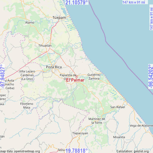
El Palmar GPS coordinates[2]
20° 26' 54.24" North, 97° 14' 42.504" West
| Map corner | latitude | longitude |
|---|---|---|
| Upper-left | 21.10579°, | -97.94827° |
| Center: | 20.4484°, | -97.24514° |
| Lower-right: | 19.78818°, | -96.54202° |
| Map W x H: | 146.5×146.5 km | = 91×91mi |
| max Lat: | 32.7° ⇑33.3% North |
| El Palmar: | 20.4484° |
| min Lat: | ⇓66.7% South 14.53588° |
| min Long | El Palmar | max Long |
| -117.105° | -97.24514° | -86.73105° |
| W 72%⇐ | ⇒28% E |
Elevation
Elevation of El Palmar is 42 m = 138 ft, and this is 1211.7 m = 3975 ft below average elevation for this country.
| Max E: |
3497 m = 11473 ft | 85.3% |
| Avg. | 1253.7 m = 4113 ft | |
| El Palmar | 42 m = 138 ft | |
Min E: |
-1 m = -3 ft | 14.7% |
See also: Mexico elevation on elevation.city.
Geographical zone
El Palmar is located in North Torrid zone (between Equator and Tropic of Cancer). Distance of this Northern Tropic circle is 332.3 km =206.5 mi to North.| Distance of | km | miles | from El Palmar |
|---|---|---|---|
| North Pole | 7733.4 | 4805.3 | to North |
| Arctic Circle | 5127.5 | 3186.1 | to North |
| Tropic Cancer | 332.3 | 206.5 | to North |
| Equator | 2273.6 | 1412.7 | to South |


Nearby cities:
15 places around El Palmar: (largest is in red/bold)
• Agua Dulce
10.7 km =6.6 mi,  207°
207°
• Carrillo Puerto
7.6 km =4.7 mi,  115°
115°
• Cerro del Carbón
6.7 km =4.2 mi,  222°
222°
• El Cedro
5.1 km =3.2 mi,  49°
49°
• El Porvenir Número Uno
8.6 km =5.3 mi, 220°
• El Remolino
7.4 km =4.6 mi,  152°
152°
• Emiliano Zapata
9.9 km =6.2 mi,  140°
140°
• Hermenegildo Galeana
9.6 km =6 mi,  79°
79°
• La Concha
6 km =3.7 mi,  304°
304°
• La Guásima
10.2 km =6.3 mi,  357°
357°
• Lomas de Arena
9.8 km =6.1 mi, 115°
• Papantla de Olarte
8.3 km =5.2 mi,  268°
268°
• Polutla
9 km =5.6 mi,  350°
350°
• San Pablo
5.8 km =3.6 mi,  74°
74°
• Totomoxtle
2.3 km =1.4 mi,  329°
329°
Sources, notices
• [Note1] Compared only with cities in Mexico existing in our database
• [Src1] Map data: © OpenStreetMap contributors (CC-BY-SA)
• [Src2] Other city data from geonames.org with taken over terms of usage.
• [Src3] Geographical zone / Annual Mean Temperature by Robert A. Rohde @ Wikipedia
