Cuanalá geodata
Cuanalá (Puebla) is a seat of a second-order administrative division; located in Mexico in America/Mexico_City (GMT-6) time zone. With population of 5,728 people, there are 1624 cities with bigger population in this country. Compared to other cities in Mexico, 62.9% of cities are located further ↑North; 59.5% of cities are located further ←West and 82% of cities have lower elevation than Cuanalá. Note1


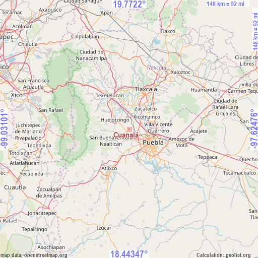
Cuanalá GPS coordinates[2]
19° 6' 33.012" North, 98° 19' 40.368" West
| Map corner | latitude | longitude |
|---|---|---|
| Upper-left | 19.7722°, | -99.03101° |
| Center: | 19.10917°, | -98.32788° |
| Lower-right: | 18.44347°, | -97.62476° |
| Map W x H: | 147.7×147.7 km | = 91.8×91.8mi |
| max Lat: | 32.7° ⇑62.9% North |
| Cuanalá: | 19.10917° |
| min Lat: | ⇓37.1% South 14.53588° |
| min Long | Cuanalá | max Long |
| -117.105° | -98.32788° | -86.73105° |
| W 59.5%⇐ | ⇒40.5% E |
Elevation
Elevation of Cuanalá is 2189 m = 7182 ft, and this is 935.3 m = 3069 ft above average elevation for this country.
| Max E: |
3497 m = 11473 ft | 18% |
| Cuanalá | 2189 m 7182 ft | |
| Avg. | 1253.7 m = 4113 ft | |
Min E: |
-1 m = -3 ft | 82% |
See also: Mexico elevation on elevation.city.
Geographical zone
Cuanalá is located in North Torrid zone (between Equator and Tropic of Cancer). Distance of this Northern Tropic circle is 481.2 km =299 mi to North.| Distance of | km | miles | from Cuanalá |
|---|---|---|---|
| North Pole | 7882.3 | 4897.8 | to North |
| Arctic Circle | 5276.4 | 3278.6 | to North |
| Tropic Cancer | 481.2 | 299 | to North |
| Equator | 2124.7 | 1320.2 | to South |


Nearby cities:
15 places around Cuanalá: (largest is in red/bold)
• Barrio de Nuevo León
4.6 km =2.9 mi,  119°
119°
• Cholula
5.6 km =3.5 mi,  152°
152°
• Coronango
2.6 km =1.6 mi,  60°
60°
• Cuautlancingo
6.1 km =3.8 mi,  110°
110°
• Fuerte de Guadalupe
5 km =3.1 mi,  129°
129°
• La Trinidad Chautenco
7.1 km =4.4 mi, 107°
• San Andrés Cholula
7.3 km =4.5 mi, 151°
• San Antonio Mihuacán
5.5 km =3.4 mi,  26°
26°
• San Diego los Sauces
4.8 km =3 mi, 132°
• San Francisco Cuapa
6 km =3.7 mi,  221°
221°
• San Francisco Ocotlán
5.4 km =3.4 mi, 59°
• San Miguel Xoxtla
6.8 km =4.2 mi,  18°
18°
• Santa María Zacatepec
4.2 km =2.6 mi,  291°
291°
• Tlaltenango
7.1 km =4.4 mi,  349°
349°
• Zacapechpan
6.6 km =4.1 mi,  201°
201°
Sources, notices
• [Note1] Compared only with cities in Mexico existing in our database
• [Src1] Map data: © OpenStreetMap contributors (CC-BY-SA)
• [Src2] Other city data from geonames.org with taken over terms of usage.
• [Src3] Geographical zone / Annual Mean Temperature by Robert A. Rohde @ Wikipedia
