San Mateo geodata
San Mateo (State of Mexico) is a populated place; located in Mexico in America/Mexico_City (GMT-6) time zone. With population of 1,750 people, there are 4965 cities with bigger population in this country. Compared to other cities in Mexico, 59.2% of cities are located further ↑North; 64.2% of cities are located further →East and 90.5% of cities have lower elevation than San Mateo. Note1


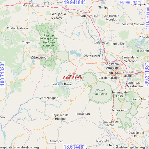
San Mateo GPS coordinates[2]
19° 16' 46.2" North, 100° 0' 54.36" West
| Map corner | latitude | longitude |
|---|---|---|
| Upper-left | 19.94184°, | -100.71823° |
| Center: | 19.2795°, | -100.0151° |
| Lower-right: | 18.61448°, | -99.31198° |
| Map W x H: | 147.6×147.6 km | = 91.7×91.7mi |
| max Lat: | 32.7° ⇑59.2% North |
| San Mateo: | 19.2795° |
| min Lat: | ⇓40.8% South 14.53588° |
| min Long | San Mateo | max Long |
| -117.105° | -100.0151° | -86.73105° |
| W 35.8%⇐ | ⇒64.2% E |
Elevation
Elevation of San Mateo is 2422 m = 7946 ft, and this is 1168.3 m = 3833 ft above average elevation for this country.
| Max E: |
3497 m = 11473 ft | 9.5% |
| San Mateo | 2422 m 7946 ft | |
| Avg. | 1253.7 m = 4113 ft | |
Min E: |
-1 m = -3 ft | 90.5% |
See also: Mexico elevation on elevation.city.
Geographical zone
San Mateo is located in North Torrid zone (between Equator and Tropic of Cancer). Distance of this Northern Tropic circle is 462.2 km =287.2 mi to North.| Distance of | km | miles | from San Mateo |
|---|---|---|---|
| North Pole | 7863.4 | 4886.1 | to North |
| Arctic Circle | 5257.5 | 3266.9 | to North |
| Tropic Cancer | 462.2 | 287.2 | to North |
| Equator | 2143.7 | 1332 | to South |


Nearby cities:
15 places around San Mateo: (largest is in red/bold)
• Amanalco de Becerra
2.9 km =1.8 mi,  189°
189°
• Amanalco de Becerra
4.1 km =2.5 mi,  357°
357°
• El Capulín Primera Seccion
6.6 km =4.1 mi,  66°
66°
• El Potrero
3.7 km =2.3 mi,  36°
36°
• Pueblo Nuevo
1.8 km =1.1 mi,  314°
314°
• Rincón de Guadalupe
2 km =1.2 mi,  107°
107°
• Sabana de Taborda 1ra. Sección
5.8 km =3.6 mi,  12°
12°
• San Antonio de la Laguna
6.4 km =4 mi,  292°
292°
• San Bartolo
5.6 km =3.5 mi,  226°
226°
• San Jerónimo
4.2 km =2.6 mi, 190°
• San Juan
4 km =2.5 mi,  203°
203°
• San Lucas
2.4 km =1.5 mi,  159°
159°
• San Miguel (San Miguel Tenextepec)
2.4 km =1.5 mi,  221°
221°
• San Sebastián el Chico
1.5 km =0.9 mi,  205°
205°
• San Sebastián el Grande
4.7 km =2.9 mi, 293°
Sources, notices
• [Note1] Compared only with cities in Mexico existing in our database
• [Src1] Map data: © OpenStreetMap contributors (CC-BY-SA)
• [Src2] Other city data from geonames.org with taken over terms of usage.
• [Src3] Geographical zone / Annual Mean Temperature by Robert A. Rohde @ Wikipedia
