Temalacayuca geodata
Temalacayuca (Puebla) is a populated place; located in Mexico in America/Mexico_City (GMT-6) time zone. With population of 2,279 people, there are 3865 cities with bigger population in this country. Compared to other cities in Mexico, 71.4% of cities are located further ↑North; 68.9% of cities are located further ←West and 68.6% of cities have lower elevation than Temalacayuca. Note1


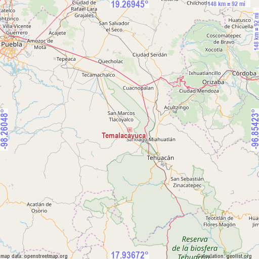
Temalacayuca GPS coordinates[2]
18° 36' 15.804" North, 97° 33' 26.46" West
| Map corner | latitude | longitude |
|---|---|---|
| Upper-left | 19.26945°, | -98.26048° |
| Center: | 18.60439°, | -97.55735° |
| Lower-right: | 17.93672°, | -96.85423° |
| Map W x H: | 148.2×148.2 km | = 92.1×92.1mi |
| max Lat: | 32.7° ⇑71.4% North |
| Temalacayuca: | 18.60439° |
| min Lat: | ⇓28.6% South 14.53588° |
| min Long | Temalacayuca | max Long |
| -117.105° | -97.55735° | -86.73105° |
| W 68.9%⇐ | ⇒31.1% E |
Elevation
Elevation of Temalacayuca is 1901 m = 6237 ft, and this is 647.3 m = 2124 ft above average elevation for this country.
| Max E: |
3497 m = 11473 ft | 31.4% |
| Temalacayuca | 1901 m 6237 ft | |
| Avg. | 1253.7 m = 4113 ft | |
Min E: |
-1 m = -3 ft | 68.6% |
See also: Mexico elevation on elevation.city.
Geographical zone
Temalacayuca is located in North Torrid zone (between Equator and Tropic of Cancer). Distance of this Northern Tropic circle is 537.3 km =333.9 mi to North.| Distance of | km | miles | from Temalacayuca |
|---|---|---|---|
| North Pole | 7938.4 | 4932.7 | to North |
| Arctic Circle | 5332.6 | 3313.5 | to North |
| Tropic Cancer | 537.3 | 333.9 | to North |
| Equator | 2068.6 | 1285.4 | to South |


Nearby cities:
15 places around Temalacayuca: (largest is in red/bold)
• Benito Juárez
9 km =5.6 mi,  121°
121°
• De Rojas
10.8 km =6.7 mi,  285°
285°
• Magdalena Cuayucatepec
9.8 km =6.1 mi,  128°
128°
• Miahuatlán
13.8 km =8.6 mi, 116°
• Pazoltepec
3 km =1.9 mi,  323°
323°
• Pericotepec
7.8 km =4.8 mi,  271°
271°
• San Andrés Cacaloapan
3.9 km =2.4 mi,  233°
233°
• San José Buenavista
6.5 km =4 mi,  339°
339°
• San José Tlacuitlapan
13.5 km =8.4 mi,  328°
328°
• San Marcos Tlacoyalco
9.1 km =5.7 mi, 327°
• Santa María la Alta
10.6 km =6.6 mi, 267°
• Tecoxtle
9 km =5.6 mi,  302°
302°
• Teontepec
12.8 km =8 mi,  166°
166°
• Tepanco
5.3 km =3.3 mi,  184°
184°
• Tlacotepec
13.5 km =8.4 mi,  309°
309°
Sources, notices
• [Note1] Compared only with cities in Mexico existing in our database
• [Src1] Map data: © OpenStreetMap contributors (CC-BY-SA)
• [Src2] Other city data from geonames.org with taken over terms of usage.
• [Src3] Geographical zone / Annual Mean Temperature by Robert A. Rohde @ Wikipedia
