Tlacotepec geodata
Tlacotepec (Puebla) is a seat of a second-order administrative division; located in Mexico in America/Mexico_City (GMT-6) time zone. With population of 8,908 people, there are 1066 cities with bigger population in this country. Compared to other cities in Mexico, 70.4% of cities are located further ↑North; 67.8% of cities are located further ←West and 70.9% of cities have lower elevation than Tlacotepec. Note1


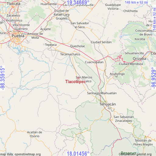
Tlacotepec GPS coordinates[2]
18° 40' 54.948" North, 97° 39' 21.672" West
| Map corner | latitude | longitude |
|---|---|---|
| Upper-left | 19.34669°, | -98.35915° |
| Center: | 18.68193°, | -97.65602° |
| Lower-right: | 18.01456°, | -96.9529° |
| Map W x H: | 148.1×148.1 km | = 92×92mi |
| max Lat: | 32.7° ⇑70.4% North |
| Tlacotepec: | 18.68193° |
| min Lat: | ⇓29.6% South 14.53588° |
| min Long | Tlacotepec | max Long |
| -117.105° | -97.65602° | -86.73105° |
| W 67.8%⇐ | ⇒32.2% E |
Elevation
Elevation of Tlacotepec is 1944 m = 6378 ft, and this is 690.3 m = 2265 ft above average elevation for this country.
| Max E: |
3497 m = 11473 ft | 29.1% |
| Tlacotepec | 1944 m 6378 ft | |
| Avg. | 1253.7 m = 4113 ft | |
Min E: |
-1 m = -3 ft | 70.9% |
See also: Mexico elevation on elevation.city.
Geographical zone
Tlacotepec is located in North Torrid zone (between Equator and Tropic of Cancer). Distance of this Northern Tropic circle is 528.7 km =328.5 mi to North.| Distance of | km | miles | from Tlacotepec |
|---|---|---|---|
| North Pole | 7929.8 | 4927.3 | to North |
| Arctic Circle | 5323.9 | 3308.1 | to North |
| Tropic Cancer | 528.7 | 328.5 | to North |
| Equator | 2077.2 | 1290.7 | to South |


Nearby cities:
15 places around Tlacotepec: (largest is in red/bold)
• De Rojas
5.8 km =3.6 mi,  180°
180°
• Guadalupe Victoria
5.9 km =3.7 mi,  256°
256°
• Ignacio Zaragoza
6.9 km =4.3 mi,  214°
214°
• Los Marías
4.4 km =2.7 mi,  351°
351°
• Rancho Chico
7.3 km =4.5 mi, 352°
• San José Tlacuitlapan
4.3 km =2.7 mi,  48°
48°
• San Lucas el Viejo
6.6 km =4.1 mi,  265°
265°
• San Marcos Tlacoyalco
5.6 km =3.5 mi,  99°
99°
• San Miguel Zozutla
8 km =5 mi,  0°
0°
• Santo Nombre
2.3 km =1.4 mi,  247°
247°
• Tecalzingo
3.8 km =2.4 mi,  333°
333°
• Tecoxtle
4.7 km =2.9 mi,  144°
144°
• Tepazolco
4.7 km =2.9 mi,  294°
294°
• Tepetlacolco
6 km =3.7 mi,  220°
220°
• Tlacomulco
6.1 km =3.8 mi, 0°
Sources, notices
• [Note1] Compared only with cities in Mexico existing in our database
• [Src1] Map data: © OpenStreetMap contributors (CC-BY-SA)
• [Src2] Other city data from geonames.org with taken over terms of usage.
• [Src3] Geographical zone / Annual Mean Temperature by Robert A. Rohde @ Wikipedia
