San Lorenzo geodata
San Lorenzo (Veracruz) is a populated place; located in Mexico in America/Mexico_City (GMT-6) time zone. With population of 952 people, there are 9147 cities with bigger population in this country. Compared to other cities in Mexico, 64.2% of cities are located further ↓South; 71.3% of cities are located further ←West and 82.2% of cities have higher elevation than San Lorenzo. Note1


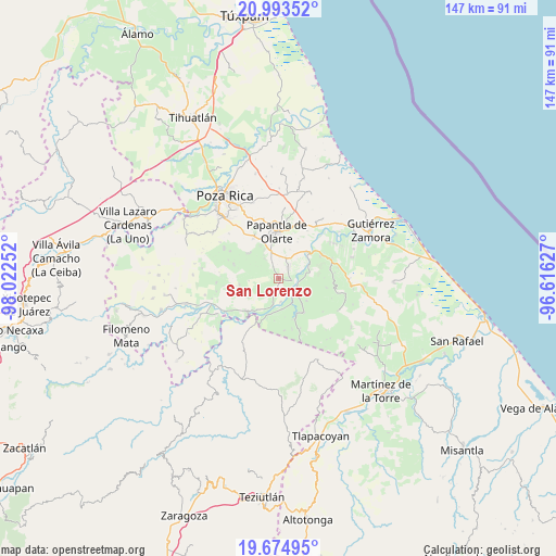
San Lorenzo GPS coordinates[2]
20° 20' 8.304" North, 97° 19' 9.804" West
| Map corner | latitude | longitude |
|---|---|---|
| Upper-left | 20.99352°, | -98.02252° |
| Center: | 20.33564°, | -97.31939° |
| Lower-right: | 19.67495°, | -96.61627° |
| Map W x H: | 146.6×146.6 km | = 91.1×91.1mi |
| max Lat: | 32.7° ⇑35.8% North |
| San Lorenzo: | 20.33564° |
| min Lat: | ⇓64.2% South 14.53588° |
| min Long | San Lorenzo | max Long |
| -117.105° | -97.31939° | -86.73105° |
| W 71.3%⇐ | ⇒28.7% E |
Elevation
Elevation of San Lorenzo is 68 m = 223 ft, and this is 1185.7 m = 3890 ft below average elevation for this country.
| Max E: |
3497 m = 11473 ft | 82.2% |
| Avg. | 1253.7 m = 4113 ft | |
| San Lorenzo | 68 m = 223 ft | |
Min E: |
-1 m = -3 ft | 17.8% |
See also: Mexico elevation on elevation.city.
Geographical zone
San Lorenzo is located in North Torrid zone (between Equator and Tropic of Cancer). Distance of this Northern Tropic circle is 344.8 km =214.2 mi to North.| Distance of | km | miles | from San Lorenzo |
|---|---|---|---|
| North Pole | 7746 | 4813.1 | to North |
| Arctic Circle | 5140.1 | 3193.9 | to North |
| Tropic Cancer | 344.8 | 214.2 | to North |
| Equator | 2261.1 | 1405 | to South |


Nearby cities:
15 places around San Lorenzo: (largest is in red/bold)
• Agua Dulce
4.1 km =2.5 mi,  41°
41°
• Arroyo del Arco
3.3 km =2.1 mi,  322°
322°
• Cerro del Carbón
8.3 km =5.2 mi,  22°
22°
• Cuyuxquihui
9.6 km =6 mi,  127°
127°
• El Cedral
9.4 km =5.8 mi,  190°
190°
• El Chote
7.8 km =4.8 mi,  340°
340°
• El Porvenir Número Uno
6.4 km =4 mi, 20°
• Francisco Villa
3.4 km =2.1 mi, 337°
• La Isla
7.3 km =4.5 mi,  82°
82°
• Mizantecatl
1 km =0.6 mi,  230°
230°
• Pajasco Limonar
8.9 km =5.5 mi,  204°
204°
• Paso de Valencia
7.2 km =4.5 mi, 191°
• Paso del Correo
5.4 km =3.4 mi,  113°
113°
• Serafín Olarte
4.5 km =2.8 mi, 340°
• Tlahuanapa
9.7 km =6 mi,  331°
331°
Sources, notices
• [Note1] Compared only with cities in Mexico existing in our database
• [Src1] Map data: © OpenStreetMap contributors (CC-BY-SA)
• [Src2] Other city data from geonames.org with taken over terms of usage.
• [Src3] Geographical zone / Annual Mean Temperature by Robert A. Rohde @ Wikipedia
