Paso de Valencia geodata
Paso de Valencia (Veracruz) is a populated place; located in Mexico in America/Mexico_City (GMT-6) time zone. With population of 1,193 people, there are 7278 cities with bigger population in this country. Compared to other cities in Mexico, 62.9% of cities are located further ↓South; 71.2% of cities are located further ←West and 83.3% of cities have higher elevation than Paso de Valencia. Note1


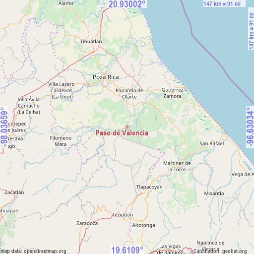
Paso de Valencia GPS coordinates[2]
20° 16' 18.696" North, 97° 20' 0.456" West
| Map corner | latitude | longitude |
|---|---|---|
| Upper-left | 20.93002°, | -98.03659° |
| Center: | 20.27186°, | -97.33346° |
| Lower-right: | 19.6109°, | -96.63034° |
| Map W x H: | 146.7×146.7 km | = 91.2×91.2mi |
| max Lat: | 32.7° ⇑37.1% North |
| Paso de Valencia: | 20.27186° |
| min Lat: | ⇓62.9% South 14.53588° |
| min Long | Paso de Valenci | max Long |
| -117.105° | -97.33346° | -86.73105° |
| W 71.2%⇐ | ⇒28.8% E |
Elevation
Elevation of Paso de Valencia is 58 m = 190 ft, and this is 1195.7 m = 3923 ft below average elevation for this country.
| Max E: |
3497 m = 11473 ft | 83.3% |
| Avg. | 1253.7 m = 4113 ft | |
| Paso de Valencia | 58 m = 190 ft | |
Min E: |
-1 m = -3 ft | 16.7% |
See also: Mexico elevation on elevation.city.
Geographical zone
Paso de Valencia is located in North Torrid zone (between Equator and Tropic of Cancer). Distance of this Northern Tropic circle is 351.9 km =218.7 mi to North.| Distance of | km | miles | from Paso de Valencia |
|---|---|---|---|
| North Pole | 7753 | 4817.5 | to North |
| Arctic Circle | 5147.2 | 3198.3 | to North |
| Tropic Cancer | 351.9 | 218.7 | to North |
| Equator | 2254 | 1400.6 | to South |


Nearby cities:
15 places around Paso de Valencia: (largest is in red/bold)
• Agua Dulce
11 km =6.8 mi,  22°
22°
• Arroyo del Arco
9.7 km =6 mi,  356°
356°
• Belisario Domínguez
7.3 km =4.5 mi,  154°
154°
• Cuyuxquihui
9.1 km =5.7 mi,  81°
81°
• El Cedral
2.1 km =1.3 mi,  185°
185°
• Espinal
7.1 km =4.4 mi,  257°
257°
• Francisco Villa
10.2 km =6.3 mi,  0°
0°
• Guadalupe Victoria
4.3 km =2.7 mi, 255°
• Joloapan
6.9 km =4.3 mi,  122°
122°
• José María Morelos
10.3 km =6.4 mi,  302°
302°
• Mizantecatl
6.5 km =4 mi,  6°
6°
• Pajasco Limonar
2.4 km =1.5 mi,  245°
245°
• Paso del Correo
8.1 km =5 mi,  52°
52°
• Pueblillo
8.4 km =5.2 mi,  103°
103°
• San Lorenzo
7.2 km =4.5 mi, 11°
Sources, notices
• [Note1] Compared only with cities in Mexico existing in our database
• [Src1] Map data: © OpenStreetMap contributors (CC-BY-SA)
• [Src2] Other city data from geonames.org with taken over terms of usage.
• [Src3] Geographical zone / Annual Mean Temperature by Robert A. Rohde @ Wikipedia
