Arroyo del Arco geodata
Arroyo del Arco (Veracruz) is a populated place; located in Mexico in America/Mexico_City (GMT-6) time zone. With population of 953 people, there are 9139 cities with bigger population in this country. Compared to other cities in Mexico, 64.7% of cities are located further ↓South; 71.2% of cities are located further ←West and 81.4% of cities have higher elevation than Arroyo del Arco. Note1


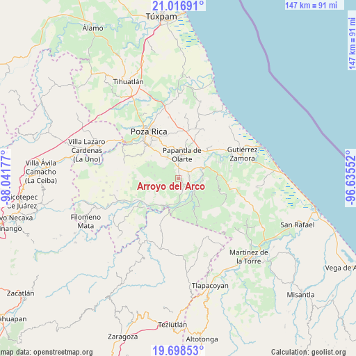
Arroyo del Arco GPS coordinates[2]
20° 21' 32.868" North, 97° 20' 19.104" West
| Map corner | latitude | longitude |
|---|---|---|
| Upper-left | 21.01691°, | -98.04177° |
| Center: | 20.35913°, | -97.33864° |
| Lower-right: | 19.69853°, | -96.63552° |
| Map W x H: | 146.6×146.6 km | = 91.1×91.1mi |
| max Lat: | 32.7° ⇑35.3% North |
| Arroyo del Arco: | 20.35913° |
| min Lat: | ⇓64.7% South 14.53588° |
| min Long | Arroyo del Arco | max Long |
| -117.105° | -97.33864° | -86.73105° |
| W 71.2%⇐ | ⇒28.8% E |
Elevation
Elevation of Arroyo del Arco is 77 m = 253 ft, and this is 1176.7 m = 3861 ft below average elevation for this country.
| Max E: |
3497 m = 11473 ft | 81.4% |
| Avg. | 1253.7 m = 4113 ft | |
| Arroyo del Arco | 77 m = 253 ft | |
Min E: |
-1 m = -3 ft | 18.6% |
See also: Mexico elevation on elevation.city.
Geographical zone
Arroyo del Arco is located in North Torrid zone (between Equator and Tropic of Cancer). Distance of this Northern Tropic circle is 342.2 km =212.6 mi to North.| Distance of | km | miles | from Arroyo del Arco |
|---|---|---|---|
| North Pole | 7743.3 | 4811.5 | to North |
| Arctic Circle | 5137.5 | 3192.3 | to North |
| Tropic Cancer | 342.2 | 212.6 | to North |
| Equator | 2263.7 | 1406.6 | to South |


Nearby cities:
15 places around Arroyo del Arco: (largest is in red/bold)
• Agua Dulce
4.8 km =3 mi,  84°
84°
• Cerro del Carbón
7.2 km =4.5 mi,  46°
46°
• Congregación el Tajín
9.1 km =5.7 mi,  330°
330°
• El Chote
4.8 km =3 mi,  353°
353°
• El Porvenir Número Uno
5.4 km =3.4 mi, 51°
• Francisco Villa
0.9 km =0.6 mi, 52°
• Gildardo Muñoz
6.9 km =4.3 mi,  306°
306°
• José María Morelos
9.2 km =5.7 mi,  242°
242°
• La Isla
9.4 km =5.8 mi,  100°
100°
• Mizantecatl
3.5 km =2.2 mi,  159°
159°
• Paso de Valencia
9.7 km =6 mi,  176°
176°
• Paso del Correo
8.4 km =5.2 mi,  124°
124°
• San Lorenzo
3.3 km =2.1 mi,  142°
142°
• Serafín Olarte
1.7 km =1.1 mi,  17°
17°
• Tlahuanapa
6.5 km =4 mi,  336°
336°
Sources, notices
• [Note1] Compared only with cities in Mexico existing in our database
• [Src1] Map data: © OpenStreetMap contributors (CC-BY-SA)
• [Src2] Other city data from geonames.org with taken over terms of usage.
• [Src3] Geographical zone / Annual Mean Temperature by Robert A. Rohde @ Wikipedia
