Paso del Correo geodata
Paso del Correo (Veracruz) is a populated place; located in Mexico in America/Mexico_City (GMT-6) time zone. With population of 1,217 people, there are 7142 cities with bigger population in this country. Compared to other cities in Mexico, 63.9% of cities are located further ↓South; 71.8% of cities are located further ←West and 86.5% of cities have higher elevation than Paso del Correo. Note1


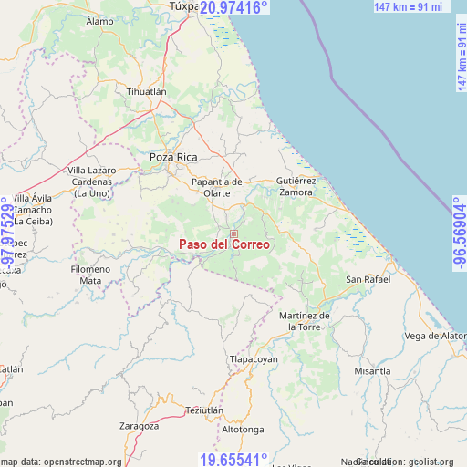
Paso del Correo GPS coordinates[2]
20° 18' 58.284" North, 97° 16' 19.776" West
| Map corner | latitude | longitude |
|---|---|---|
| Upper-left | 20.97416°, | -97.97529° |
| Center: | 20.31619°, | -97.27216° |
| Lower-right: | 19.65541°, | -96.56904° |
| Map W x H: | 146.6×146.6 km | = 91.1×91.1mi |
| max Lat: | 32.7° ⇑36.1% North |
| Paso del Correo: | 20.31619° |
| min Lat: | ⇓63.9% South 14.53588° |
| min Long | Paso del Correo | max Long |
| -117.105° | -97.27216° | -86.73105° |
| W 71.8%⇐ | ⇒28.2% E |
Elevation
Elevation of Paso del Correo is 36 m = 118 ft, and this is 1217.7 m = 3995 ft below average elevation for this country.
| Max E: |
3497 m = 11473 ft | 86.5% |
| Avg. | 1253.7 m = 4113 ft | |
| Paso del Correo | 36 m = 118 ft | |
Min E: |
-1 m = -3 ft | 13.5% |
See also: Mexico elevation on elevation.city.
Geographical zone
Paso del Correo is located in North Torrid zone (between Equator and Tropic of Cancer). Distance of this Northern Tropic circle is 347 km =215.6 mi to North.| Distance of | km | miles | from Paso del Correo |
|---|---|---|---|
| North Pole | 7748.1 | 4814.4 | to North |
| Arctic Circle | 5142.2 | 3195.2 | to North |
| Tropic Cancer | 347 | 215.6 | to North |
| Equator | 2258.9 | 1403.6 | to South |


Nearby cities:
15 places around Paso del Correo: (largest is in red/bold)
• Agua Dulce
5.7 km =3.5 mi,  337°
337°
• Arroyo del Arco
8.4 km =5.2 mi,  304°
304°
• Cerro del Carbón
9.9 km =6.2 mi,  350°
350°
• Cuyuxquihui
4.5 km =2.8 mi,  143°
143°
• El Cedral
9.7 km =6 mi,  223°
223°
• El Porvenir Número Uno
8.6 km =5.3 mi, 341°
• Francisco Villa
8.2 km =5.1 mi,  310°
310°
• Ignacio Allende
7.9 km =4.9 mi,  91°
91°
• Joloapan
8.7 km =5.4 mi,  183°
183°
• La Isla
3.9 km =2.4 mi,  36°
36°
• Mizantecatl
5.9 km =3.7 mi,  284°
284°
• Paso de Valencia
8.1 km =5 mi,  232°
232°
• Pueblillo
7.1 km =4.4 mi,  165°
165°
• San Lorenzo
5.4 km =3.4 mi,  293°
293°
• Serafín Olarte
9.1 km =5.7 mi, 314°
Sources, notices
• [Note1] Compared only with cities in Mexico existing in our database
• [Src1] Map data: © OpenStreetMap contributors (CC-BY-SA)
• [Src2] Other city data from geonames.org with taken over terms of usage.
• [Src3] Geographical zone / Annual Mean Temperature by Robert A. Rohde @ Wikipedia
