San Juan Achiutla geodata
San Juan Achiutla (Oaxaca) is a seat of a second-order administrative division; located in Mexico in America/Mexico_City (GMT-6) time zone. With population of 146 people, there are 16893 cities with bigger population in this country. Compared to other cities in Mexico, 84.7% of cities are located further ↑North; 69.4% of cities are located further ←West and 75% of cities have lower elevation than San Juan Achiutla. Note1


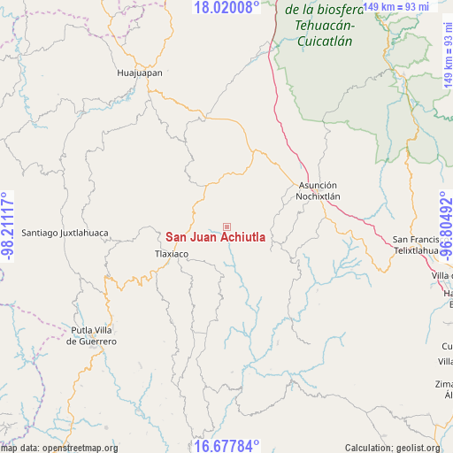
San Juan Achiutla GPS coordinates[2]
17° 21' 0.684" North, 97° 30' 28.944" West
| Map corner | latitude | longitude |
|---|---|---|
| Upper-left | 18.02008°, | -98.21117° |
| Center: | 17.35019°, | -97.50804° |
| Lower-right: | 16.67784°, | -96.80492° |
| Map W x H: | 149.2×149.2 km | = 92.7×92.7mi |
| max Lat: | 32.7° ⇑84.7% North |
| San Juan Achiutla: | 17.35019° |
| min Lat: | ⇓15.3% South 14.53588° |
| min Long | San Juan Achiut | max Long |
| -117.105° | -97.50804° | -86.73105° |
| W 69.4%⇐ | ⇒30.6% E |
Elevation
Elevation of San Juan Achiutla is 2030 m = 6660 ft, and this is 776.3 m = 2547 ft above average elevation for this country.
| Max E: |
3497 m = 11473 ft | 25% |
| San Juan Achiutla | 2030 m 6660 ft | |
| Avg. | 1253.7 m = 4113 ft | |
Min E: |
-1 m = -3 ft | 75% |
See also: Mexico elevation on elevation.city.
Geographical zone
San Juan Achiutla is located in North Torrid zone (between Equator and Tropic of Cancer). Distance of this Northern Tropic circle is 676.8 km =420.5 mi to North.| Distance of | km | miles | from San Juan Achiutla |
|---|---|---|---|
| North Pole | 8077.9 | 5019.4 | to North |
| Arctic Circle | 5472 | 3400.1 | to North |
| Tropic Cancer | 676.8 | 420.5 | to North |
| Equator | 1929.2 | 1198.7 | to South |


Nearby cities:
15 places around San Juan Achiutla: (largest is in red/bold)
• Magdalena Yodocono de Porfirio Díaz
16.7 km =10.4 mi,  76°
76°
• San Cristóbal Amoltepec
10 km =6.2 mi,  222°
222°
• San Isidro
16.3 km =10.1 mi,  204°
204°
• San Juan Diuxi
16.3 km =10.1 mi,  115°
115°
• San Miguel Achiutla
5.2 km =3.2 mi,  150°
150°
• San Pedro Mártir Yucuxaco
14.2 km =8.8 mi,  309°
309°
• San Pedro Tidaá
14.4 km =8.9 mi,  93°
93°
• San Pedro Ñumí
17.4 km =10.8 mi,  279°
279°
• San Vicente Nuñu
13.7 km =8.5 mi,  30°
30°
• Santa Catarina Tayata
5.3 km =3.3 mi,  266°
266°
• Santa Cruz Tayata
6.5 km =4 mi, 276°
• Santa María Nduayaco
6.8 km =4.2 mi,  13°
13°
• Santa María del Rosario
9.2 km =5.7 mi, 271°
• Santiago Nejapilla
16.2 km =10.1 mi,  61°
61°
• Santiago Yolomécatl
15.1 km =9.4 mi,  334°
334°
Sources, notices
• [Note1] Compared only with cities in Mexico existing in our database
• [Src1] Map data: © OpenStreetMap contributors (CC-BY-SA)
• [Src2] Other city data from geonames.org with taken over terms of usage.
• [Src3] Geographical zone / Annual Mean Temperature by Robert A. Rohde @ Wikipedia
