La Concepción Enyege geodata
La Concepción Enyege (State of Mexico) is a populated place; located in Mexico in America/Mexico_City (GMT-6) time zone. With population of 2,180 people, there are 4031 cities with bigger population in this country. Compared to other cities in Mexico, 52.7% of cities are located further ↑North; 62% of cities are located further →East and 93.5% of cities have lower elevation than La Concepción Enyege. Note1
Current local time in La Concepción Enyege:
08:33 AM, WednesdayDifference from your time zone: hours


La Concepción Enyege GPS coordinates[2]
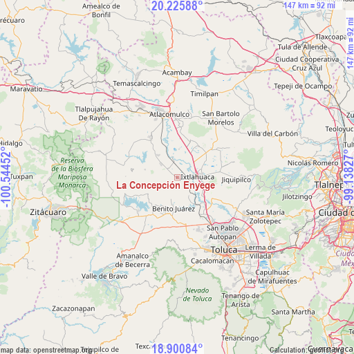
19° 33' 52.992" North, 99° 50' 29.004" West
| Map corner | latitude | longitude |
|---|---|---|
| Upper-left | 20.22588°, | -100.54452° |
| Center: | 19.56472°, | -99.84139° |
| Lower-right: | 18.90084°, | -99.13827° |
| Map W x H: | 147.3×147.3 km | = 91.5×91.5mi |
| max Lat: | 32.7° ⇑52.7% North |
| La Concepción Enyege: | 19.56472° |
| min Lat: | ⇓47.3% South 14.53588° |
| min Long | La Concepción | max Long |
| -117.105° | -99.84139° | -86.73105° |
| W 38%⇐ | ⇒62% E |
Elevation
Elevation of La Concepción Enyege is 2552 m = 8373 ft, and this is 1298.3 m = 4260 ft above average elevation for this country.
| Max E: |
3497 m = 11473 ft | 6.5% |
| La Concepción Enyege | 2552 m 8373 ft | |
| Avg. | 1253.7 m = 4113 ft | |
Min E: |
-1 m = -3 ft | 93.5% |
See also: Mexico elevation on elevation.city.
Geographical zone
La Concepción Enyege is located in North Torrid zone (between Equator and Tropic of Cancer). Distance of this Northern Tropic circle is 430.5 km =267.5 mi to North.| Distance of | km | miles | from La Concepción Enyege |
|---|---|---|---|
| North Pole | 7831.7 | 4866.4 | to North |
| Arctic Circle | 5225.8 | 3247.2 | to North |
| Tropic Cancer | 430.5 | 267.5 | to North |
| Equator | 2175.4 | 1351.7 | to South |


Nearby cities:
15 places around La Concepción Enyege: (largest is in red/bold)
• Dolores Enyege
0.9 km =0.6 mi,  306°
306°
• El Rincón de los Perales
2.9 km =1.8 mi,  150°
150°
• Emiliano Zapata (Santo Domingo)
5.8 km =3.6 mi,  73°
73°
• Guadalupe Cachi
4.4 km =2.7 mi,  22°
22°
• San Andrés del Pedregal
3.4 km =2.1 mi,  302°
302°
• San Ignacio del Pedregal
4.8 km =3 mi,  345°
345°
• San Ildefonso
5.8 km =3.6 mi,  93°
93°
• San Isidro Boxipe
6.6 km =4.1 mi, 307°
• San Juan de las Manzanas
1.5 km =0.9 mi,  168°
168°
• San Mateo Ixtlahuaca
6.3 km =3.9 mi,  42°
42°
• San Miguel Enyege
2 km =1.2 mi,  286°
286°
• San Pedro Los Baños
7.1 km =4.4 mi, 17°
• San Pedro el Alto
4.6 km =2.9 mi, 297°
• Santa Ana Ixtlahuaca (Santa Ana Ixtlahuacingo)
5.3 km =3.3 mi, 294°
• Santa Ana la Ladera
4.6 km =2.9 mi,  319°
319°
Sources, notices
• [Note1] Compared only with cities in Mexico existing in our database
• [Src1] Map data: © OpenStreetMap contributors (CC-BY-SA)
• [Src2] Other city data from geonames.org with taken over terms of usage.
• [Src3] Geographical zone / Annual Mean Temperature by Robert A. Rohde @ Wikipedia
