San Gabriel geodata
San Gabriel (Hidalgo) is a populated place; located in Mexico in America/Mexico_City (GMT-6) time zone. With population of 2,557 people, there are 3461 cities with bigger population in this country. Compared to other cities in Mexico, 60.7% of cities are located further ↓South; 54.6% of cities are located further →East and 75.1% of cities have lower elevation than San Gabriel. Note1


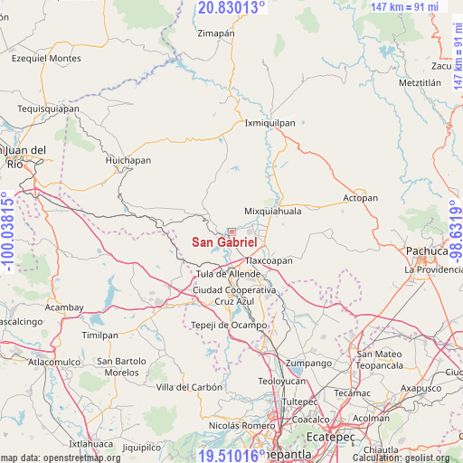
San Gabriel GPS coordinates[2]
20° 10' 17.544" North, 99° 20' 6.072" West
| Map corner | latitude | longitude |
|---|---|---|
| Upper-left | 20.83013°, | -100.03815° |
| Center: | 20.17154°, | -99.33502° |
| Lower-right: | 19.51016°, | -98.6319° |
| Map W x H: | 146.8×146.8 km | = 91.2×91.2mi |
| max Lat: | 32.7° ⇑39.3% North |
| San Gabriel: | 20.17154° |
| min Lat: | ⇓60.7% South 14.53588° |
| min Long | San Gabriel | max Long |
| -117.105° | -99.33502° | -86.73105° |
| W 45.4%⇐ | ⇒54.6% E |
Elevation
Elevation of San Gabriel is 2032 m = 6667 ft, and this is 778.3 m = 2553 ft above average elevation for this country.
| Max E: |
3497 m = 11473 ft | 24.9% |
| San Gabriel | 2032 m 6667 ft | |
| Avg. | 1253.7 m = 4113 ft | |
Min E: |
-1 m = -3 ft | 75.1% |
See also: Mexico elevation on elevation.city.
Geographical zone
San Gabriel is located in North Torrid zone (between Equator and Tropic of Cancer). Distance of this Northern Tropic circle is 363.1 km =225.6 mi to North.| Distance of | km | miles | from San Gabriel |
|---|---|---|---|
| North Pole | 7764.2 | 4824.4 | to North |
| Arctic Circle | 5158.3 | 3205.2 | to North |
| Tropic Cancer | 363.1 | 225.6 | to North |
| Equator | 2242.9 | 1393.7 | to South |


Nearby cities:
15 places around San Gabriel: (largest is in red/bold)
• Atengo
0.9 km =0.6 mi,  63°
63°
• Colonia Ampliación (Segunda Manzana)
4.3 km =2.7 mi,  294°
294°
• Colonia San Juan
5.8 km =3.6 mi,  69°
69°
• General Pedro María Anaya
2.2 km =1.4 mi,  218°
218°
• Huitel
5.9 km =3.7 mi,  94°
94°
• La Cuarta Manzana
5.8 km =3.6 mi,  283°
283°
• La Loma
4.6 km =2.9 mi,  267°
267°
• Panuaya
7.2 km =4.5 mi, 68°
• San Isidro el Tanque
5 km =3.1 mi, 85°
• San Juan Achichilco
2.3 km =1.4 mi, 69°
• San Pedro Nextlalpan
5.9 km =3.7 mi,  247°
247°
• Santa Ana Ahuehuepan
5.5 km =3.4 mi,  190°
190°
• Santiago Acayutlán
5 km =3.1 mi, 55°
• Tepetitlan
5.1 km =3.2 mi, 290°
• Tezontepec de Aldama
6.7 km =4.2 mi, 71°
Sources, notices
• [Note1] Compared only with cities in Mexico existing in our database
• [Src1] Map data: © OpenStreetMap contributors (CC-BY-SA)
• [Src2] Other city data from geonames.org with taken over terms of usage.
• [Src3] Geographical zone / Annual Mean Temperature by Robert A. Rohde @ Wikipedia
