Huitel geodata
Huitel (Hidalgo) is a populated place; located in Mexico in America/Mexico_City (GMT-6) time zone. With population of 5,390 people, there are 1721 cities with bigger population in this country. Compared to other cities in Mexico, 60.6% of cities are located further ↓South; 54% of cities are located further →East and 76% of cities have lower elevation than Huitel. Note1


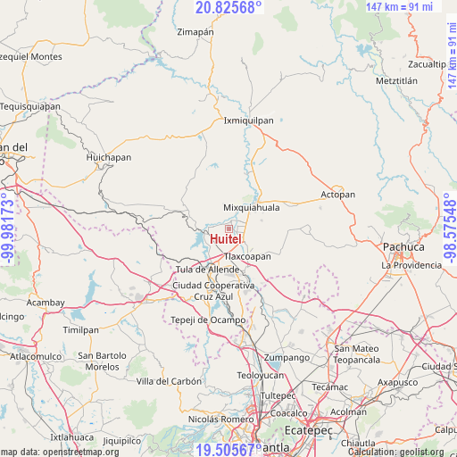
Huitel GPS coordinates[2]
20° 10' 1.452" North, 99° 16' 42.96" West
| Map corner | latitude | longitude |
|---|---|---|
| Upper-left | 20.82568°, | -99.98173° |
| Center: | 20.16707°, | -99.2786° |
| Lower-right: | 19.50567°, | -98.57548° |
| Map W x H: | 146.8×146.8 km | = 91.2×91.2mi |
| max Lat: | 32.7° ⇑39.4% North |
| Huitel: | 20.16707° |
| min Lat: | ⇓60.6% South 14.53588° |
| min Long | Huitel | max Long |
| -117.105° | -99.2786° | -86.73105° |
| W 46%⇐ | ⇒54% E |
Elevation
Elevation of Huitel is 2049 m = 6722 ft, and this is 795.3 m = 2609 ft above average elevation for this country.
| Max E: |
3497 m = 11473 ft | 24% |
| Huitel | 2049 m 6722 ft | |
| Avg. | 1253.7 m = 4113 ft | |
Min E: |
-1 m = -3 ft | 76% |
See also: Mexico elevation on elevation.city.
Geographical zone
Huitel is located in North Torrid zone (between Equator and Tropic of Cancer). Distance of this Northern Tropic circle is 363.6 km =225.9 mi to North.| Distance of | km | miles | from Huitel |
|---|---|---|---|
| North Pole | 7764.7 | 4824.8 | to North |
| Arctic Circle | 5158.8 | 3205.5 | to North |
| Tropic Cancer | 363.6 | 225.9 | to North |
| Equator | 2242.4 | 1393.4 | to South |


Nearby cities:
15 places around Huitel: (largest is in red/bold)
• Atengo
5.1 km =3.2 mi,  280°
280°
• Colonia Lázaro Cárdenas
4.7 km =2.9 mi,  122°
122°
• Colonia San Juan
2.6 km =1.6 mi,  350°
350°
• La Cruz
4 km =2.5 mi,  75°
75°
• La Loma
2 km =1.2 mi,  53°
53°
• La Palma
6 km =3.7 mi,  23°
23°
• Mangas
3.9 km =2.4 mi,  55°
55°
• Panuaya
3.2 km =2 mi,  14°
14°
• Presas
2.9 km =1.8 mi,  107°
107°
• San Gabriel
5.9 km =3.7 mi,  274°
274°
• San Isidro el Tanque
1.2 km =0.7 mi,  315°
315°
• San Juan Achichilco
4 km =2.5 mi,  288°
288°
• Santiago Acayutlán
3.8 km =2.4 mi,  332°
332°
• Tezontepec de Aldama
2.7 km =1.7 mi, 9°
• Tlahuelilpan
6.4 km =4 mi,  129°
129°
Sources, notices
• [Note1] Compared only with cities in Mexico existing in our database
• [Src1] Map data: © OpenStreetMap contributors (CC-BY-SA)
• [Src2] Other city data from geonames.org with taken over terms of usage.
• [Src3] Geographical zone / Annual Mean Temperature by Robert A. Rohde @ Wikipedia
