San Miguel Aguacomulican geodata
San Miguel Aguacomulican (Puebla) is a populated place; located in Mexico in America/Mexico_City (GMT-6) time zone. With population of 1,107 people, there are 7851 cities with bigger population in this country. Compared to other cities in Mexico, 68.4% of cities are located further ↑North; 56.6% of cities are located further ←West and 61.2% of cities have lower elevation than San Miguel Aguacomulican. Note1
Current local time in San Miguel Aguacomulican:
10:03 AM, MondayDifference from your time zone: hours


San Miguel Aguacomulican GPS coordinates[2]
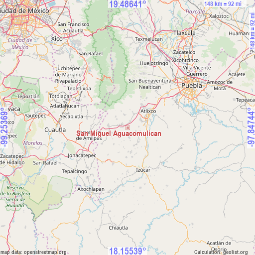
18° 49' 19.992" North, 98° 33' 2.016" West
| Map corner | latitude | longitude |
|---|---|---|
| Upper-left | 19.48641°, | -99.25369° |
| Center: | 18.82222°, | -98.55056° |
| Lower-right: | 18.15539°, | -97.84744° |
| Map W x H: | 148×148 km | = 92×92mi |
| max Lat: | 32.7° ⇑68.4% North |
| San Miguel Aguacomulican: | 18.82222° |
| min Lat: | ⇓31.6% South 14.53588° |
| min Long | San Miguel Agua | max Long |
| -117.105° | -98.55056° | -86.73105° |
| W 56.6%⇐ | ⇒43.4% E |
Elevation
Elevation of San Miguel Aguacomulican is 1747 m = 5732 ft, and this is 493.3 m = 1618 ft above average elevation for this country.
| Max E: |
3497 m = 11473 ft | 38.8% |
| San Miguel Aguacomulican | 1747 m 5732 ft | |
| Avg. | 1253.7 m = 4113 ft | |
Min E: |
-1 m = -3 ft | 61.2% |
See also: Mexico elevation on elevation.city.
Geographical zone
San Miguel Aguacomulican is located in North Torrid zone (between Equator and Tropic of Cancer). Distance of this Northern Tropic circle is 513.1 km =318.8 mi to North.| Distance of | km | miles | from San Miguel Aguacomulican |
|---|---|---|---|
| North Pole | 7914.2 | 4917.7 | to North |
| Arctic Circle | 5308.3 | 3298.4 | to North |
| Tropic Cancer | 513.1 | 318.8 | to North |
| Equator | 2092.8 | 1300.4 | to South |


Nearby cities:
15 places around San Miguel Aguacomulican: (largest is in red/bold)
• Cacaloxúchitl
7.8 km =4.8 mi,  119°
119°
• Huaquechula
5.7 km =3.5 mi,  173°
173°
• Huilango
4.1 km =2.5 mi,  305°
305°
• San Francisco Xochiteopan
8 km =5 mi,  255°
255°
• San Jerónimo Coyula
8.8 km =5.5 mi,  23°
23°
• San Juan Tejupa
3.8 km =2.4 mi,  14°
14°
• Santiago Atzitzihuacán
3.3 km =2.1 mi,  274°
274°
• Santiago Tetla
7.8 km =4.8 mi, 169°
• Santiago Tochimizolco
8.1 km =5 mi, 308°
• Soledad Morelos
6.5 km =4 mi,  84°
84°
• Teacalco de Dorantes (San José Teacalco)
5 km =3.1 mi,  113°
113°
• Tlapetlahuaya
7.8 km =4.8 mi,  196°
196°
• Tochimilco
7.9 km =4.9 mi,  343°
343°
• Tronconal
7.3 km =4.5 mi, 105°
• Tulcingo
5 km =3.1 mi,  289°
289°
Sources, notices
• [Note1] Compared only with cities in Mexico existing in our database
• [Src1] Map data: © OpenStreetMap contributors (CC-BY-SA)
• [Src2] Other city data from geonames.org with taken over terms of usage.
• [Src3] Geographical zone / Annual Mean Temperature by Robert A. Rohde @ Wikipedia
