San Buenaventura geodata
San Buenaventura (Hidalgo) is a populated place; located in Mexico in America/Mexico_City (GMT-6) time zone. With population of 3,949 people, there are 2307 cities with bigger population in this country. Compared to other cities in Mexico, 53.3% of cities are located further ↓South; 54.4% of cities are located further →East and 82.6% of cities have lower elevation than San Buenaventura. Note1


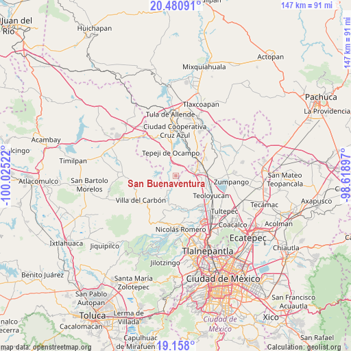
San Buenaventura GPS coordinates[2]
19° 49' 14.988" North, 99° 19' 19.524" West
| Map corner | latitude | longitude |
|---|---|---|
| Upper-left | 20.48091°, | -100.02522° |
| Center: | 19.82083°, | -99.32209° |
| Lower-right: | 19.158°, | -98.61897° |
| Map W x H: | 147.1×147.1 km | = 91.4×91.4mi |
| max Lat: | 32.7° ⇑46.7% North |
| San Buenaventura: | 19.82083° |
| min Lat: | ⇓53.3% South 14.53588° |
| min Long | San Buenaventur | max Long |
| -117.105° | -99.32209° | -86.73105° |
| W 45.6%⇐ | ⇒54.4% E |
Elevation
Elevation of San Buenaventura is 2205 m = 7234 ft, and this is 951.3 m = 3121 ft above average elevation for this country.
| Max E: |
3497 m = 11473 ft | 17.4% |
| San Buenaventura | 2205 m 7234 ft | |
| Avg. | 1253.7 m = 4113 ft | |
Min E: |
-1 m = -3 ft | 82.6% |
See also: Mexico elevation on elevation.city.
Geographical zone
San Buenaventura is located in North Torrid zone (between Equator and Tropic of Cancer). Distance of this Northern Tropic circle is 402 km =249.8 mi to North.| Distance of | km | miles | from San Buenaventura |
|---|---|---|---|
| North Pole | 7803.2 | 4848.7 | to North |
| Arctic Circle | 5197.3 | 3229.5 | to North |
| Tropic Cancer | 402 | 249.8 | to North |
| Equator | 2203.9 | 1369.4 | to South |


Nearby cities:
15 places around San Buenaventura: (largest is in red/bold)
• Cantera de Villagrán
2.6 km =1.6 mi,  31°
31°
• Jorobas
7.7 km =4.8 mi,  87°
87°
• La Loma
4.5 km =2.8 mi,  227°
227°
• Loma Alta Taxhimay
9.3 km =5.8 mi,  284°
284°
• San Ignacio Nopala
2.9 km =1.8 mi,  303°
303°
• San José Piedra Gorda
4.4 km =2.7 mi,  245°
245°
• San Luis Anáhuac (Toriles)
8.6 km =5.3 mi, 251°
• San Luis Taxhimay
8.3 km =5.2 mi, 284°
• Santa María Quelites
4.6 km =2.9 mi,  323°
323°
• Santiago Tlaltepoxco
9.5 km =5.9 mi,  42°
42°
• Santiago Tlapanaloya
6.3 km =3.9 mi,  331°
331°
• Taxhido
8 km =5 mi,  336°
336°
• Tepeji del Río de Ocampo
9.6 km =6 mi,  346°
346°
• Unidad San Miguel Jagüeyes
3.5 km =2.2 mi,  84°
84°
• Villa URBI del Rey
7.2 km =4.5 mi,  71°
71°
Sources, notices
• [Note1] Compared only with cities in Mexico existing in our database
• [Src1] Map data: © OpenStreetMap contributors (CC-BY-SA)
• [Src2] Other city data from geonames.org with taken over terms of usage.
• [Src3] Geographical zone / Annual Mean Temperature by Robert A. Rohde @ Wikipedia
