Villa URBI del Rey geodata
Villa URBI del Rey (State of Mexico) is a populated place; located in Mexico in America/Mexico_City (GMT-6) time zone. With population of 3,616 people, there are 2536 cities with bigger population in this country. Compared to other cities in Mexico, 53.8% of cities are located further ↓South; 53.7% of cities are located further →East and 88.3% of cities have lower elevation than Villa URBI del Rey. Note1


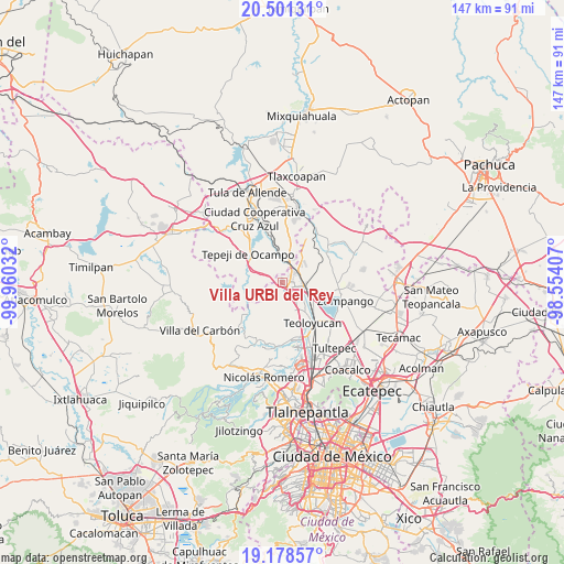
Villa URBI del Rey GPS coordinates[2]
19° 50' 28.752" North, 99° 15' 25.884" West
| Map corner | latitude | longitude |
|---|---|---|
| Upper-left | 20.50131°, | -99.96032° |
| Center: | 19.84132°, | -99.25719° |
| Lower-right: | 19.17857°, | -98.55407° |
| Map W x H: | 147.1×147.1 km | = 91.4×91.4mi |
| max Lat: | 32.7° ⇑46.2% North |
| Villa URBI del Rey: | 19.84132° |
| min Lat: | ⇓53.8% South 14.53588° |
| min Long | Villa URBI del | max Long |
| -117.105° | -99.25719° | -86.73105° |
| W 46.3%⇐ | ⇒53.7% E |
Elevation
Elevation of Villa URBI del Rey is 2352 m = 7717 ft, and this is 1098.3 m = 3603 ft above average elevation for this country.
| Max E: |
3497 m = 11473 ft | 11.7% |
| Villa URBI del Rey | 2352 m 7717 ft | |
| Avg. | 1253.7 m = 4113 ft | |
Min E: |
-1 m = -3 ft | 88.3% |
See also: Mexico elevation on elevation.city.
Geographical zone
Villa URBI del Rey is located in North Torrid zone (between Equator and Tropic of Cancer). Distance of this Northern Tropic circle is 399.8 km =248.4 mi to North.| Distance of | km | miles | from Villa URBI del Rey |
|---|---|---|---|
| North Pole | 7800.9 | 4847.3 | to North |
| Arctic Circle | 5195 | 3228 | to North |
| Tropic Cancer | 399.8 | 248.4 | to North |
| Equator | 2206.1 | 1370.8 | to South |


Nearby cities:
15 places around Villa URBI del Rey: (largest is in red/bold)
• Barranca Prieta
4.8 km =3 mi,  71°
71°
• Cantera de Villagrán
5.4 km =3.4 mi,  269°
269°
• Casa Nueva
5.1 km =3.2 mi,  100°
100°
• Ex-hacienda de Xalpa
8.1 km =5 mi,  105°
105°
• Huehuetoca
5.8 km =3.6 mi, 104°
• Jorobas
2.1 km =1.3 mi,  154°
154°
• Paseos de la Pradera
5.9 km =3.7 mi,  19°
19°
• Praderas del Potrero
5.6 km =3.5 mi,  30°
30°
• Salitrillo
4.5 km =2.8 mi, 107°
• San Bartolo
6.8 km =4.2 mi, 97°
• San Buenaventura
7.2 km =4.5 mi,  251°
251°
• San Pedro Xalpa
7.8 km =4.8 mi, 102°
• Santa Teresa
2.5 km =1.6 mi,  80°
80°
• Santiago Tlaltepoxco
4.7 km =2.9 mi,  355°
355°
• Unidad San Miguel Jagüeyes
3.9 km =2.4 mi,  239°
239°
Sources, notices
• [Note1] Compared only with cities in Mexico existing in our database
• [Src1] Map data: © OpenStreetMap contributors (CC-BY-SA)
• [Src2] Other city data from geonames.org with taken over terms of usage.
• [Src3] Geographical zone / Annual Mean Temperature by Robert A. Rohde @ Wikipedia
