San Bartolo Oxtotitlán geodata
San Bartolo Oxtotitlán (State of Mexico) is a populated place; located in Mexico in America/Mexico_City (GMT-6) time zone. With population of 5,155 people, there are 1798 cities with bigger population in this country. Compared to other cities in Mexico, 51.5% of cities are located further ↑North; 58.8% of cities are located further →East and 97.8% of cities have lower elevation than San Bartolo Oxtotitlán. Note1
Current local time in San Bartolo Oxtotitlán:
10:46 PM, TuesdayDifference from your time zone: hours


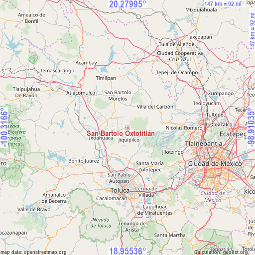
San Bartolo Oxtotitlán GPS coordinates[2]
19° 37' 8.472" North, 99° 36' 48.492" West
| Map corner | latitude | longitude |
|---|---|---|
| Upper-left | 20.27995°, | -100.3166° |
| Center: | 19.61902°, | -99.61347° |
| Lower-right: | 18.95536°, | -98.91035° |
| Map W x H: | 147.3×147.3 km | = 91.5×91.5mi |
| max Lat: | 32.7° ⇑51.5% North |
| San Bartolo Oxtotitlán: | 19.61902° |
| min Lat: | ⇓48.5% South 14.53588° |
| min Long | San Bartolo Oxt | max Long |
| -117.105° | -99.61347° | -86.73105° |
| W 41.2%⇐ | ⇒58.8% E |
Elevation
Elevation of San Bartolo Oxtotitlán is 2731 m = 8960 ft, and this is 1477.3 m = 4847 ft above average elevation for this country.
| Max E: |
3497 m = 11473 ft | 2.2% |
| San Bartolo Oxtotitlán | 2731 m 8960 ft | |
| Avg. | 1253.7 m = 4113 ft | |
Min E: |
-1 m = -3 ft | 97.8% |
See also: Mexico elevation on elevation.city.
Geographical zone
San Bartolo Oxtotitlán is located in North Torrid zone (between Equator and Tropic of Cancer). Distance of this Northern Tropic circle is 424.5 km =263.8 mi to North.| Distance of | km | miles | from San Bartolo Oxtotitlán |
|---|---|---|---|
| North Pole | 7825.6 | 4862.6 | to North |
| Arctic Circle | 5219.7 | 3243.4 | to North |
| Tropic Cancer | 424.5 | 263.8 | to North |
| Equator | 2181.4 | 1355.5 | to South |


Nearby cities:
15 places around San Bartolo Oxtotitlán: (largest is in red/bold)
• Buenos Aires
5.7 km =3.5 mi,  268°
268°
• Ejido de Santa María Nativitas
5.8 km =3.6 mi,  205°
205°
• Loma Hermosa
2.5 km =1.6 mi,  314°
314°
• Loma Hidalgo Colonia Benito Juárez
4 km =2.5 mi,  229°
229°
• Loma Vicente Guerrero
5.8 km =3.6 mi, 226°
• Loma de Buenavista
2 km =1.2 mi,  2°
2°
• Manzana Segunda
6.1 km =3.8 mi,  160°
160°
• Manzana Tercera (Bodo)
5.5 km =3.4 mi,  167°
167°
• Manzana Tercera Loma de Hidalgo
5.4 km =3.4 mi, 233°
• Moxteje
5.8 km =3.6 mi,  200°
200°
• Pueblo Nuevo
6.1 km =3.8 mi,  356°
356°
• San José del Sitio
5.8 km =3.6 mi,  251°
251°
• San Lorenzo Malacota
3.4 km =2.1 mi, 359°
• Santa María Nativitas
4.4 km =2.7 mi, 173°
• Tlalpujahuilla
4.4 km =2.7 mi,  332°
332°
Sources, notices
• [Note1] Compared only with cities in Mexico existing in our database
• [Src1] Map data: © OpenStreetMap contributors (CC-BY-SA)
• [Src2] Other city data from geonames.org with taken over terms of usage.
• [Src3] Geographical zone / Annual Mean Temperature by Robert A. Rohde @ Wikipedia
