Pueblo Nuevo geodata
Pueblo Nuevo (State of Mexico) is a populated place; located in Mexico in America/Mexico_City (GMT-6) time zone. With population of 3,940 people, there are 2315 cities with bigger population in this country. Compared to other cities in Mexico, 50.3% of cities are located further ↑North; 58.9% of cities are located further →East and 98.5% of cities have lower elevation than Pueblo Nuevo. Note1


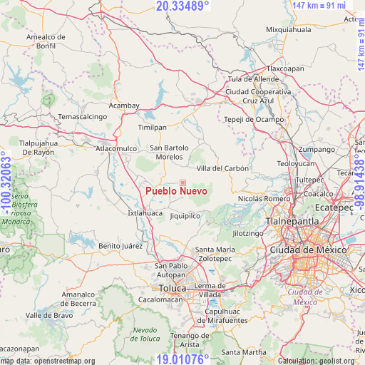
Pueblo Nuevo GPS coordinates[2]
19° 40' 27.084" North, 99° 37' 3" West
| Map corner | latitude | longitude |
|---|---|---|
| Upper-left | 20.33489°, | -100.32063° |
| Center: | 19.67419°, | -99.6175° |
| Lower-right: | 19.01076°, | -98.91438° |
| Map W x H: | 147.2×147.2 km | = 91.5×91.5mi |
| max Lat: | 32.7° ⇑50.3% North |
| Pueblo Nuevo: | 19.67419° |
| min Lat: | ⇓49.7% South 14.53588° |
| min Long | Pueblo Nuevo | max Long |
| -117.105° | -99.6175° | -86.73105° |
| W 41.1%⇐ | ⇒58.9% E |
Elevation
Elevation of Pueblo Nuevo is 2787 m = 9144 ft, and this is 1533.3 m = 5031 ft above average elevation for this country.
| Max E: |
3497 m = 11473 ft | 1.5% |
| Pueblo Nuevo | 2787 m 9144 ft | |
| Avg. | 1253.7 m = 4113 ft | |
Min E: |
-1 m = -3 ft | 98.5% |
See also: Mexico elevation on elevation.city.
Geographical zone
Pueblo Nuevo is located in North Torrid zone (between Equator and Tropic of Cancer). Distance of this Northern Tropic circle is 418.4 km =260 mi to North.| Distance of | km | miles | from Pueblo Nuevo |
|---|---|---|---|
| North Pole | 7819.5 | 4858.8 | to North |
| Arctic Circle | 5213.6 | 3239.6 | to North |
| Tropic Cancer | 418.4 | 260 | to North |
| Equator | 2187.6 | 1359.3 | to South |


Nearby cities:
15 places around Pueblo Nuevo: (largest is in red/bold)
• Barrio de Boyecha
7.9 km =4.9 mi,  298°
298°
• Buenos Aires
8.2 km =5.1 mi,  219°
219°
• Colonia Emiliano Zapata
4.2 km =2.6 mi,  287°
287°
• Ejido Loma de Malacota
5.9 km =3.7 mi,  251°
251°
• La Cruz (San Simón la Cruz)
6.8 km =4.2 mi,  26°
26°
• Loma Hermosa
4.6 km =2.9 mi,  196°
196°
• Loma de Buenavista
4.2 km =2.6 mi,  173°
173°
• Rancho Alegre
8.8 km =5.5 mi,  231°
231°
• San Antonio Nixini
7 km =4.3 mi,  270°
270°
• San Bartolo Oxtotitlán
6.1 km =3.8 mi,  176°
176°
• San José la Epifania
5.4 km =3.4 mi,  331°
331°
• San Lorenzo Malacota
2.8 km =1.7 mi, 171°
• San Sebastián Buenos Aires
6.1 km =3.8 mi,  13°
13°
• Santa Clara de Juárez
5.1 km =3.2 mi, 12°
• Tlalpujahuilla
2.8 km =1.7 mi, 216°
Sources, notices
• [Note1] Compared only with cities in Mexico existing in our database
• [Src1] Map data: © OpenStreetMap contributors (CC-BY-SA)
• [Src2] Other city data from geonames.org with taken over terms of usage.
• [Src3] Geographical zone / Annual Mean Temperature by Robert A. Rohde @ Wikipedia
