Zoyatzingo geodata
Zoyatzingo (State of Mexico) is a populated place; located in Mexico in America/Mexico_City (GMT-6) time zone. With population of 2,795 people, there are 3173 cities with bigger population in this country. Compared to other cities in Mexico, 63.3% of cities are located further ↑North; 53.9% of cities are located further ←West and 91.9% of cities have lower elevation than Zoyatzingo. Note1


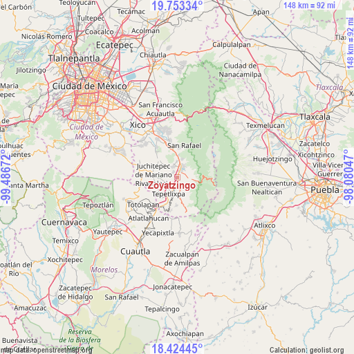
Zoyatzingo GPS coordinates[2]
19° 5' 24.828" North, 98° 47' 0.924" West
| Map corner | latitude | longitude |
|---|---|---|
| Upper-left | 19.75334°, | -99.48672° |
| Center: | 19.09023°, | -98.78359° |
| Lower-right: | 18.42445°, | -98.08047° |
| Map W x H: | 147.8×147.8 km | = 91.8×91.8mi |
| max Lat: | 32.7° ⇑63.3% North |
| Zoyatzingo: | 19.09023° |
| min Lat: | ⇓36.7% South 14.53588° |
| min Long | Zoyatzingo | max Long |
| -117.105° | -98.78359° | -86.73105° |
| W 53.9%⇐ | ⇒46.1% E |
Elevation
Elevation of Zoyatzingo is 2479 m = 8133 ft, and this is 1225.3 m = 4020 ft above average elevation for this country.
| Max E: |
3497 m = 11473 ft | 8.1% |
| Zoyatzingo | 2479 m 8133 ft | |
| Avg. | 1253.7 m = 4113 ft | |
Min E: |
-1 m = -3 ft | 91.9% |
See also: Mexico elevation on elevation.city.
Geographical zone
Zoyatzingo is located in North Torrid zone (between Equator and Tropic of Cancer). Distance of this Northern Tropic circle is 483.3 km =300.3 mi to North.| Distance of | km | miles | from Zoyatzingo |
|---|---|---|---|
| North Pole | 7884.4 | 4899.1 | to North |
| Arctic Circle | 5278.5 | 3279.9 | to North |
| Tropic Cancer | 483.3 | 300.3 | to North |
| Equator | 2122.6 | 1318.9 | to South |


Nearby cities:
15 places around Zoyatzingo: (largest is in red/bold)
• Amecameca
4.1 km =2.5 mi,  25°
25°
• Ayapango
4.4 km =2.7 mi,  337°
337°
• La Colonia
6 km =3.7 mi,  356°
356°
• Las Delicias
2.1 km =1.3 mi,  172°
172°
• Mihuacan
3.3 km =2.1 mi,  307°
307°
• Ozumba de Alzate
6.1 km =3.8 mi,  191°
191°
• Pahuacán
3 km =1.9 mi, 308°
• Popo Park
2.8 km =1.7 mi, 174°
• Poxtla
5.5 km =3.4 mi, 344°
• San Diego Chalcatepehuacán
3.9 km =2.4 mi,  6°
6°
• San Diego Huehuecalco
2.1 km =1.3 mi,  82°
82°
• San Juan Tehuixtitlán
4.4 km =2.7 mi,  156°
156°
• San Mateo Tecalco
4.3 km =2.7 mi,  197°
197°
• San Pedro Nexapa
4.9 km =3 mi,  98°
98°
• Zentlalpan
6.7 km =4.2 mi, 358°
Sources, notices
• [Note1] Compared only with cities in Mexico existing in our database
• [Src1] Map data: © OpenStreetMap contributors (CC-BY-SA)
• [Src2] Other city data from geonames.org with taken over terms of usage.
• [Src3] Geographical zone / Annual Mean Temperature by Robert A. Rohde @ Wikipedia
