San Mateo Tecalco geodata
San Mateo Tecalco (State of Mexico) is a populated place; located in Mexico in America/Mexico_City (GMT-6) time zone. With population of 2,897 people, there are 3072 cities with bigger population in this country. Compared to other cities in Mexico, 63.8% of cities are located further ↑North; 53.7% of cities are located further ←West and 89% of cities have lower elevation than San Mateo Tecalco. Note1


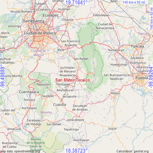
San Mateo Tecalco GPS coordinates[2]
19° 3' 11.34" North, 98° 47' 44.736" West
| Map corner | latitude | longitude |
|---|---|---|
| Upper-left | 19.71641°, | -99.49889° |
| Center: | 19.05315°, | -98.79576° |
| Lower-right: | 18.38723°, | -98.09264° |
| Map W x H: | 147.8×147.8 km | = 91.8×91.8mi |
| max Lat: | 32.7° ⇑63.8% North |
| San Mateo Tecalco: | 19.05315° |
| min Lat: | ⇓36.2% South 14.53588° |
| min Long | San Mateo Tecal | max Long |
| -117.105° | -98.79576° | -86.73105° |
| W 53.7%⇐ | ⇒46.3% E |
Elevation
Elevation of San Mateo Tecalco is 2374 m = 7789 ft, and this is 1120.3 m = 3676 ft above average elevation for this country.
| Max E: |
3497 m = 11473 ft | 11% |
| San Mateo Tecalco | 2374 m 7789 ft | |
| Avg. | 1253.7 m = 4113 ft | |
Min E: |
-1 m = -3 ft | 89% |
See also: Mexico elevation on elevation.city.
Geographical zone
San Mateo Tecalco is located in North Torrid zone (between Equator and Tropic of Cancer). Distance of this Northern Tropic circle is 487.4 km =302.9 mi to North.| Distance of | km | miles | from San Mateo Tecalco |
|---|---|---|---|
| North Pole | 7888.6 | 4901.7 | to North |
| Arctic Circle | 5282.7 | 3282.5 | to North |
| Tropic Cancer | 487.4 | 302.9 | to North |
| Equator | 2118.5 | 1316.4 | to South |


Nearby cities:
15 places around San Mateo Tecalco: (largest is in red/bold)
• Atlautla
3.9 km =2.4 mi,  152°
152°
• Cuecuecuatitla
6.7 km =4.2 mi,  228°
228°
• Las Delicias
2.6 km =1.6 mi,  36°
36°
• Mihuacan
6.3 km =3.9 mi,  347°
347°
• Ozumba de Alzate
1.8 km =1.1 mi,  178°
178°
• Pahuacán
6.1 km =3.8 mi, 350°
• Popo Park
2.1 km =1.3 mi,  49°
49°
• San Diego Huehuecalco
5.6 km =3.5 mi, 37°
• San Juan Tehuixtitlán
3 km =1.9 mi,  87°
87°
• San Matías Cuijingo
7 km =4.3 mi,  300°
300°
• San Pedro Nexapa
7 km =4.3 mi,  61°
61°
• San Vicente Chimalhuacán
3.3 km =2.1 mi,  190°
190°
• Santiago Mamalhuazuca
6.3 km =3.9 mi, 180°
• Tepetlixpa
3.8 km =2.4 mi,  224°
224°
• Zoyatzingo
4.3 km =2.7 mi,  17°
17°
Sources, notices
• [Note1] Compared only with cities in Mexico existing in our database
• [Src1] Map data: © OpenStreetMap contributors (CC-BY-SA)
• [Src2] Other city data from geonames.org with taken over terms of usage.
• [Src3] Geographical zone / Annual Mean Temperature by Robert A. Rohde @ Wikipedia
