Poxtla geodata
Poxtla (State of Mexico) is a populated place; located in Mexico in America/Mexico_City (GMT-6) time zone. With population of 923 people, there are 9459 cities with bigger population in this country. Compared to other cities in Mexico, 62.4% of cities are located further ↑North; 53.7% of cities are located further ←West and 91.3% of cities have lower elevation than Poxtla. Note1


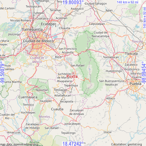
Poxtla GPS coordinates[2]
19° 8' 16.836" North, 98° 47' 51.576" West
| Map corner | latitude | longitude |
|---|---|---|
| Upper-left | 19.80093°, | -99.50079° |
| Center: | 19.13801°, | -98.79766° |
| Lower-right: | 18.47242°, | -98.09454° |
| Map W x H: | 147.7×147.7 km | = 91.8×91.8mi |
| max Lat: | 32.7° ⇑62.4% North |
| Poxtla: | 19.13801° |
| min Lat: | ⇓37.6% South 14.53588° |
| min Long | Poxtla | max Long |
| -117.105° | -98.79766° | -86.73105° |
| W 53.7%⇐ | ⇒46.3% E |
Elevation
Elevation of Poxtla is 2455 m = 8054 ft, and this is 1201.3 m = 3941 ft above average elevation for this country.
| Max E: |
3497 m = 11473 ft | 8.7% |
| Poxtla | 2455 m 8054 ft | |
| Avg. | 1253.7 m = 4113 ft | |
Min E: |
-1 m = -3 ft | 91.3% |
See also: Mexico elevation on elevation.city.
Geographical zone
Poxtla is located in North Torrid zone (between Equator and Tropic of Cancer). Distance of this Northern Tropic circle is 478 km =297 mi to North.| Distance of | km | miles | from Poxtla |
|---|---|---|---|
| North Pole | 7879.1 | 4895.8 | to North |
| Arctic Circle | 5273.2 | 3276.6 | to North |
| Tropic Cancer | 478 | 297 | to North |
| Equator | 2127.9 | 1322.2 | to South |


Nearby cities:
15 places around Poxtla: (largest is in red/bold)
• Amecameca
3.6 km =2.2 mi,  115°
115°
• Ayapango
1.3 km =0.8 mi,  190°
190°
• La Colonia
1.4 km =0.9 mi,  58°
58°
• Mihuacan
3.5 km =2.2 mi,  199°
199°
• Pahuacán
3.5 km =2.2 mi, 193°
• San Antonio Tlaltecahuacán
3.7 km =2.3 mi,  53°
53°
• San Diego Chalcatepehuacán
2.4 km =1.5 mi,  126°
126°
• San Diego Huehuecalco
6.2 km =3.9 mi,  144°
144°
• San Juan Coxtocan
5.2 km =3.2 mi,  271°
271°
• Santa Isabel Chalma
4 km =2.5 mi, 57°
• Santiago Cuautenco
5.5 km =3.4 mi,  78°
78°
• Santo Tomás Atzingo
4.3 km =2.7 mi,  27°
27°
• Tlamapa
4.1 km =2.5 mi,  275°
275°
• Zentlalpan
1.9 km =1.2 mi,  44°
44°
• Zoyatzingo
5.5 km =3.4 mi,  164°
164°
Sources, notices
• [Note1] Compared only with cities in Mexico existing in our database
• [Src1] Map data: © OpenStreetMap contributors (CC-BY-SA)
• [Src2] Other city data from geonames.org with taken over terms of usage.
• [Src3] Geographical zone / Annual Mean Temperature by Robert A. Rohde @ Wikipedia
