San Antonio Chum geodata
San Antonio Chum (Yucatán) is a populated place; located in Mexico in America/Merida (GMT-6) time zone. With population of 904 people, there are 9652 cities with bigger population in this country. Compared to other cities in Mexico, 74.4% of cities are located further ↓South; 97.7% of cities are located further ←West and 97.5% of cities have higher elevation than San Antonio Chum. Note1


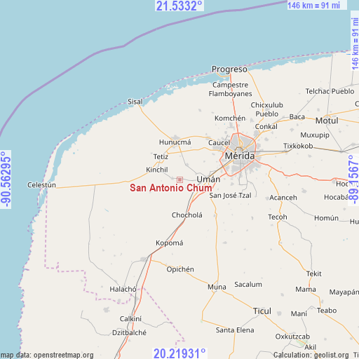
San Antonio Chum GPS coordinates[2]
20° 52' 39.684" North, 89° 51' 35.352" West
| Map corner | latitude | longitude |
|---|---|---|
| Upper-left | 21.5332°, | -90.56295° |
| Center: | 20.87769°, | -89.85982° |
| Lower-right: | 20.21931°, | -89.1567° |
| Map W x H: | 146.1×146.1 km | = 90.8×90.8mi |
| max Lat: | 32.7° ⇑25.6% North |
| San Antonio Chum: | 20.87769° |
| min Lat: | ⇓74.4% South 14.53588° |
| min Long | San Antonio Chu | max Long |
| -117.105° | -89.85982° | -86.73105° |
| W 97.7%⇐ | ⇒2.3% E |
Elevation
Elevation of San Antonio Chum is 9 m = 30 ft, and this is 1244.7 m = 4084 ft below average elevation for this country.
| Max E: |
3497 m = 11473 ft | 97.5% |
| Avg. | 1253.7 m = 4113 ft | |
| San Antonio Chum | 9 m = 30 ft | |
Min E: |
-1 m = -3 ft | 2.5% |
See also: Mexico elevation on elevation.city.
Geographical zone
San Antonio Chum is located in North Torrid zone (between Equator and Tropic of Cancer). Distance of this Northern Tropic circle is 284.5 km =176.8 mi to North.| Distance of | km | miles | from San Antonio Chum |
|---|---|---|---|
| North Pole | 7685.7 | 4775.7 | to North |
| Arctic Circle | 5079.8 | 3156.4 | to North |
| Tropic Cancer | 284.5 | 176.8 | to North |
| Equator | 2321.4 | 1442.5 | to South |


Nearby cities:
15 places around San Antonio Chum: (largest is in red/bold)
• Bolón
4.2 km =2.6 mi,  136°
136°
• Chochola
14.4 km =8.9 mi,  167°
167°
• Dzibikak
7.2 km =4.5 mi,  69°
69°
• Hunucmá
15.6 km =9.7 mi,  354°
354°
• Kinchil
10.1 km =6.3 mi,  294°
294°
• Kuchel
5 km =3.1 mi,  232°
232°
• Nohuayun
15.7 km =9.8 mi,  313°
313°
• Oxcum
12.6 km =7.8 mi,  53°
53°
• Poxila
8.8 km =5.5 mi, 138°
• Samahil
3 km =1.9 mi,  282°
282°
• San Antonio Tedzidz
12.9 km =8 mi,  248°
248°
• Tetiz
12.2 km =7.6 mi,  321°
321°
• Texan de Palomeque
7.2 km =4.5 mi,  22°
22°
• Uman
11.8 km =7.3 mi,  87°
87°
• Xtepen
13.6 km =8.5 mi,  116°
116°
Sources, notices
• [Note1] Compared only with cities in Mexico existing in our database
• [Src1] Map data: © OpenStreetMap contributors (CC-BY-SA)
• [Src2] Other city data from geonames.org with taken over terms of usage.
• [Src3] Geographical zone / Annual Mean Temperature by Robert A. Rohde @ Wikipedia
