Bolón geodata
Bolón (Yucatán) is a populated place; located in Mexico in America/Merida (GMT-6) time zone. With population of 1,392 people, there are 6215 cities with bigger population in this country. Compared to other cities in Mexico, 74% of cities are located further ↓South; 97.7% of cities are located further ←West and 97.5% of cities have higher elevation than Bolón. Note1


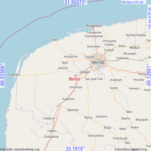
Bolón GPS coordinates[2]
20° 51' 0.36" North, 89° 49' 54.948" West
| Map corner | latitude | longitude |
|---|---|---|
| Upper-left | 21.50573°, | -90.53506° |
| Center: | 20.8501°, | -89.83193° |
| Lower-right: | 20.1916°, | -89.12881° |
| Map W x H: | 146.1×146.1 km | = 90.8×90.8mi |
| max Lat: | 32.7° ⇑26% North |
| Bolón: | 20.8501° |
| min Lat: | ⇓74% South 14.53588° |
| min Long | Bolón | max Long |
| -117.105° | -89.83193° | -86.73105° |
| W 97.7%⇐ | ⇒2.3% E |
Elevation
Elevation of Bolón is 9 m = 30 ft, and this is 1244.7 m = 4084 ft below average elevation for this country.
| Max E: |
3497 m = 11473 ft | 97.5% |
| Avg. | 1253.7 m = 4113 ft | |
| Bolón | 9 m = 30 ft | |
Min E: |
-1 m = -3 ft | 2.5% |
See also: Mexico elevation on elevation.city.
Geographical zone
Bolón is located in North Torrid zone (between Equator and Tropic of Cancer). Distance of this Northern Tropic circle is 287.6 km =178.7 mi to North.| Distance of | km | miles | from Bolón |
|---|---|---|---|
| North Pole | 7688.7 | 4777.5 | to North |
| Arctic Circle | 5082.9 | 3158.4 | to North |
| Tropic Cancer | 287.6 | 178.7 | to North |
| Equator | 2318.3 | 1440.5 | to South |


Nearby cities:
15 places around Bolón: (largest is in red/bold)
• Chochola
11 km =6.8 mi,  179°
179°
• Dzibikak
6.8 km =4.2 mi,  34°
34°
• Itzincab Palomeque
15.7 km =9.8 mi,  62°
62°
• Kinchil
14.1 km =8.8 mi,  300°
300°
• Kuchel
6.8 km =4.2 mi,  270°
270°
• Oxcum
12.8 km =8 mi, 34°
• Poxila
4.6 km =2.9 mi,  141°
141°
• Samahil
6.9 km =4.3 mi, 302°
• San Antonio Chum
4.2 km =2.6 mi,  316°
316°
• San Antonio Tedzidz
15 km =9.3 mi,  263°
263°
• Texan de Palomeque
9.7 km =6 mi,  359°
359°
• Ticimul
15.8 km =9.8 mi,  77°
77°
• Tizcacal Opichen
16.1 km =10 mi,  49°
49°
• Uman
9.6 km =6 mi,  68°
68°
• Xtepen
9.7 km =6 mi,  108°
108°
Sources, notices
• [Note1] Compared only with cities in Mexico existing in our database
• [Src1] Map data: © OpenStreetMap contributors (CC-BY-SA)
• [Src2] Other city data from geonames.org with taken over terms of usage.
• [Src3] Geographical zone / Annual Mean Temperature by Robert A. Rohde @ Wikipedia
